Freie Waldorfschule Uhlandshöhe
Freie Waldorfschule Uhlandshöhe is a school in Stuttgart, Stuttgart Region, Baden-Württemberg. Freie Waldorfschule Uhlandshöhe is situated nearby to the sports venue Turnhalle, as well as near the scenic viewpoint Aussichtsplattform Uhlandshöhe.| Tap on a place to explore it |
Places of Interest Nearby
Highlights include Stuttgart Observatory and national gallery.
Stuttgart Observatory

Photo: Wikimedia, CC BY-SA 2.5.
Stuttgart Observatory is an astronomical observatory owned and operated by the volunteer association Schwäbische Sternwarte e.V. It is located on the hill Uhlandshöhe in Stuttgart, Germany. The Observatory is accessible to the public since 1922. Stuttgart Observatory is situated 160 metres east of Freie Waldorfschule Uhlandshöhe.
national gallery
Museum
 The Staatsgalerie Stuttgart is an art museum in Stuttgart, Germany, it opened in 1843. In 1984, the opening of the Neue Staatsgalerie designed by James Stirling transformed the once provincial gallery into one of Europe's leading museums. national gallery is situated 580 metres southwest of Freie Waldorfschule Uhlandshöhe.
Stuttgart main station
Railway station
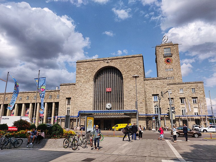
Photo: Dining Car, CC BY-SA 2.0.
Stuttgart Hauptbahnhof is the primary railway station in the city of Stuttgart, the state capital of Baden-Württemberg, in southwestern Germany. It is the largest regional and long-distance railway station in Stuttgart, the main node of the Stuttgart S-Bahn network, and, together with the station at Charlottenplatz, it is the main node of the Stuttgart Stadtbahn. Stuttgart main station is situated 1 km northwest of Freie Waldorfschule Uhlandshöhe.
Places in the Area
Nearby places include Stuttgart-Center and Postdörfle.
Stuttgart-Center
Suburb

Photo: Wikimedia, CC BY-SA 3.0.
Stuttgart-Center is one of the five inner boroughs of the Germany city of Stuttgart. It is located at the very center, between Stuttgart-North, West, East and South, of the city on the banks of the Neckar about an hour from the Black Forest.

Bad Cannstatt
Suburb

Photo: Stinchen, CC BY-SA 4.0.
Bad Cannstatt, also called Cannstatt or Kannstadt, is one of the outer Stadtbezirke, or city boroughs, of Stuttgart in Baden-Württemberg, Germany. Bad Cannstatt is the oldest and most populous of Stuttgart's boroughs, and one of the most historically significant towns in the area of Stuttgart. Bad Cannstatt is situated 3 km northeast of Freie Waldorfschule Uhlandshöhe.
Freie Waldorfschule Uhlandshöhe
- Type: School
- Wheelchair access: no
- Categories: Waldorf school and education
- Location: Stuttgart, Stuttgart, Stuttgart Region, Baden-Württemberg, Germany, Central Europe, Europe
- View on OpenStreetMap
Latitude
48.78227° or 48° 46′ 56″ northLongitude
9.19427° or 9° 11′ 39″ eastOpen location code
8FWFQ5JV+WPOpenStreetMap ID
way 515825410OpenStreetMap feature
amenity=schoolOpenStreetMap attribute
wheelchair=noWikidata ID
Q56477169
This page is based on OpenStreetMap, Wikidata, and Wikimedia Commons.
We’d love your help improving our open data sources. Thank you for contributing.
Satellite Map
Discover Freie Waldorfschule Uhlandshöhe from above in high-definition satellite imagery.
In Other Languages
“Freie Waldorfschule Uhlandshöhe” goes by many names.
- German: “Freie Waldorfschule Uhlandshöhe”
Notable Places Nearby
Highlights include Turnhalle and Aussichtsplattform Uhlandshöhe.
Nearby Places
Explore places such as Saalbau and Hochschule.
Stuttgart Region: Must-Visit Destinations
Delve into Ludwigsburg, Esslingen, Sindelfingen, and Waiblingen.
Curious Schools to Discover
Uncover intriguing schools from every corner of the globe.
About Mapcarta. Data © OpenStreetMap contributors and available under the Open Database License". Text is available under the CC BY-SA 4.0 license, except for photos, directions, and the map. Photo: Hd pano, CC BY-SA 3.0 de.