Banque Islamique du Sénégal
Banque Islamique du Sénégal is a bank in Dakar, Senegal. Banque Islamique du Sénégal is situated nearby to the government office Embassy of Ukraine, Dakar, as well as near Feed the future.| Tap on a place to explore it |
Places of Interest Nearby
Highlights include Aéroport International Léopold Sédar Senghor and African Renaissance Monument.
Aéroport International Léopold Sédar Senghor
Aerodrome
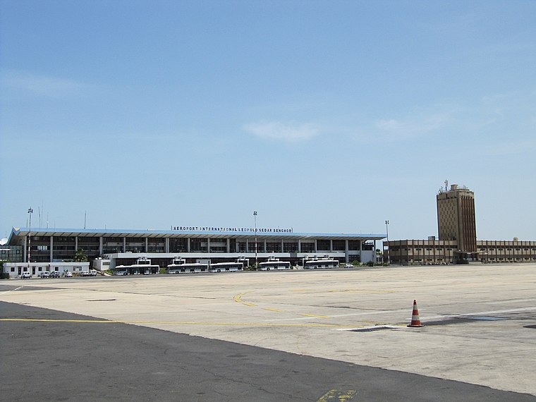
Photo: Popo le Chien, Public domain.
Léopold Sédar Senghor International Airport is an international freight and former passenger airport serving Dakar, the capital of Senegal. The airport is situated near the town of Yoff, a northern suburb of Dakar. Aéroport International Léopold Sédar Senghor is situated 3 km east of Banque Islamique du Sénégal.
African Renaissance Monument
Monument

Photo: Jeff Attaway, CC BY 2.0.
The African Renaissance Monument is a 52-metre tall bronze statue located on top of one of the twin hills known as Collines des Mamelles, outside Dakar, Senegal. African Renaissance Monument is situated 3 km southeast of Banque Islamique du Sénégal.
Les Mamelles Lighthouse
Scenic viewpoint

Photo: Ji-Elle, Public domain.
Les Mamelles Lighthouse is a strategically important lighthouse situated near Cap Vert, the westernmost point of Africa, on the outskirts of Dakar the capital of Senegal. Les Mamelles Lighthouse is situated 2½ km southeast of Banque Islamique du Sénégal.
Places in the Area
Nearby places include Almadies Arrondissement and Almadi Point.
Almadies Arrondissement
Neighborhood
Almadies Arrondissement is an arrondissement of the Dakar Department in the Dakar Region of Senegal. Almadies is considered the most upmarket residential neighbourhood in Central & Western Africa and it holds the residences of numerous foreign Ambassadors and expatriates.
Almadi Point
Locality
 Pointe des Almadies or Point Almadies is the westernmost point on the continent of Africa and of the Afro-Eurasian landmass, lying at 17.5 degrees west of the Greenwich meridian, 8 degrees further west than Cabo da Roca, mainland Europe's westernmost point.
Yoff
Neighborhood

Photo: Arensond, Public domain.
Yoff is a town, part of the city of Dakar, located in Senegal. It lies north of downtown Dakar and immediately north of Léopold Sédar Senghor International Airport. Yoff is situated 4 km northeast of Banque Islamique du Sénégal.
Banque Islamique du Sénégal
- Type: Bank
- Categories: building and commercial building
- Location: Dakar, Senegal, West Africa, Africa
- View on OpenStreetMap
Latitude
14.74428° or 14° 44′ 39″ northLongitude
-17.5111° or 17° 30′ 40″ westOpen location code
7C64PFVQ+PHOpenStreetMap ID
way 521519090OpenStreetMap feature
amenity=bankOpenStreetMap feature
building=commercial
This page is based on OpenStreetMap, Wikidata, and Wikimedia Commons.
We’d love your help improving our open data sources. Thank you for contributing.
Satellite Map
Discover Banque Islamique du Sénégal from above in high-definition satellite imagery.
Places with the Same Name
Discover other places named “Banque Islamique du Sénégal”.
Notable Places Nearby
Highlights include Embassy of Ukraine, Dakar and Feed the future.
Nearby Places
Explore places such as fruits and Save the Children.
Senegal: Must-Visit Destinations
Delve into Dakar, Saint-Louis, Niokolo-Koba, and Ziguinchor.
Curious Banks to Discover
Uncover intriguing banks from every corner of the globe.
About Mapcarta. Data © OpenStreetMap contributors and available under the Open Database License". Text is available under the CC BY-SA 4.0 license, except for photos, directions, and the map. Photo: Wikimedia, CC0.