Comarca Gudar-Javalambre
Comarca Gudar-Javalambre is a government building in Mora de Rubielos Municipality, Teruel, Aragon. Comarca Gudar-Javalambre is situated nearby to the college Instituto de Educación Secundaria Gúdar-Javalambre, as well as near the church Ermita de San Miguel.| Tap on a place to explore it |
Places of Interest Nearby
Highlights include Castle of Mora de Rubielos.
Castle of Mora de Rubielos
Castle
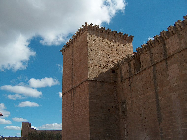
Photo: Millars, CC BY-SA 3.0 es.
Castle of Mora de Rubielos is situated 1 km north of Comarca Gudar-Javalambre.
Places in the Area
Nearby places include Valbona Municipality and Cabra de Mora.
Valbona Municipality
Village
Photo: 19Tarrestnom65, CC BY-SA 4.0.
Valbona is a municipality located in the province of Teruel, Aragon, Spain. According to the 2004 census, the municipality had a population of 212 inhabitants. Valbona Municipality is situated 6 km west of Comarca Gudar-Javalambre.
Cabra de Mora
Village

Photo: popsique, CC BY-SA 2.0.
Cabra de Mora is a municipality in the province of Teruel, Aragon, Spain. According to the 2004 census, it had a population of 119. By 2018, the population had declined to just 55 residents reflecting a steady decrease since 2007. Cabra de Mora is situated 9 km northwest of Comarca Gudar-Javalambre.
Nogueruelas Municipality
Village

Photo: Wikimedia, CC BY-SA 3.0.
Nogueruelas is a municipality located in the province of Teruel, Aragon, Spain. According to the 2004 census, the municipality had a population of 227 inhabitants. Nogueruelas Municipality is situated 10 km east of Comarca Gudar-Javalambre.
Comarca Gudar-Javalambre
- Type: Government building
- Categories: government office, building, and office
- Location: Mora de Rubielos Municipality, Teruel, Aragon, Northern Spain, Spain, Iberia, Europe
- View on OpenStreetMap
Latitude
40.24606° or 40° 14′ 46″ northLongitude
-0.75012° or 0° 45′ 0″ westOpen location code
8CGX66WX+CXOpenStreetMap ID
way 534311784OpenStreetMap feature
building=governmentOpenStreetMap feature
office=government
This page is based on OpenStreetMap, Wikidata, and Wikimedia Commons.
We’d love your help improving our open data sources. Thank you for contributing.
Satellite Map
Discover Comarca Gudar-Javalambre from above in high-definition satellite imagery.
Notable Places Nearby
Highlights include Instituto de Educación Secundaria Gúdar-Javalambre and Ermita de San Miguel.
Nearby Places
Explore places such as Mapfre and Pura Trufa.
Aragon: Must-Visit Destinations
Delve into Zaragoza, Huesca, Teruel, and Calatayud.
Curious Government Buildings to Discover
Uncover intriguing government buildings from every corner of the globe.
About Mapcarta. Data © OpenStreetMap contributors and available under the Open Database License". Text is available under the CC BY-SA 4.0 license, except for photos, directions, and the map. Photo: Javidlf, CC BY-SA 4.0.