Mittelschule Frauenkirchen
Mittelschule Frauenkirchen is a school building in Frauenkirchen, Neusiedl am See District, Burgenland which is located on Kirchenplatz. Mittelschule Frauenkirchen is situated nearby to the wayside shrine Mariensäule, Frauenkirchen, as well as near the town hall Stadtgemeinde Frauenkirchen.| Tap on a place to explore it |
- Email: nms@cluster-frauenkirchen.at
- Type: School building
- Address: Kirchenplatz 1d, Frauenkirchen, 7132
Places of Interest Nearby
Highlights include Basilika Mariä Geburt, Frauenkirchen and Mariensäule, Frauenkirchen.
Basilika Mariä Geburt, Frauenkirchen
Church
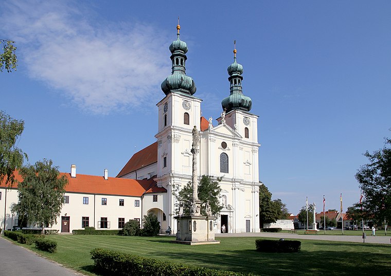
Photo: Bwag, CC BY-SA 3.0 at.
Basilika Mariä Geburt, Frauenkirchen is a church, which is situated 130 metres southeast of Mittelschule Frauenkirchen.
Mariensäule, Frauenkirchen
Wayside shrine

Photo: Bwag, CC BY-SA 3.0 at.
Mariensäule, Frauenkirchen is a wayside shrine.
Kalvarienberg, Frauenkirchen

Photo: P e z i, CC BY-SA 3.0 at.
Kalvarienberg, Frauenkirchen is situated 200 metres southeast of Mittelschule Frauenkirchen.
Places in the Area
Nearby places include Halbturn and Gols.
Halbturn
Village
Photo: BambooBeast, Public domain.
Halbturn is a town in the district of Neusiedl am See in the Austrian state of Burgenland. It borders Hungary to the east and is near Andau, Gols, and Mönchof. Halbturn is situated 5 km northeast of Mittelschule Frauenkirchen.
Gols
Village

Photo: Steindy, CC BY-SA 4.0.
Gols is a town in the district of Neusiedl am See in the Austrian state of Burgenland. Gols is situated 7 km north of Mittelschule Frauenkirchen.
Albertkázmérpuszta
Hamlet

Photo: Pasztilla, CC BY-SA 4.0.
Albertkázmérpuszta is a hamlet, which is situated 8 km northeast of Mittelschule Frauenkirchen.
Mittelschule Frauenkirchen
- Categories: building and education
- Location: Frauenkirchen, Neusiedl am See District, Burgenland, Austria, Central Europe, Europe
- View on OpenStreetMap
Latitude
47.8367° or 47° 50′ 12″ northLongitude
16.92742° or 16° 55′ 39″ eastLevels
3Open location code
8FVRRWPG+MXOpenStreetMap ID
way 536219062OpenStreetMap feature
building=school
This page is based on OpenStreetMap, Wikidata, and Wikimedia Commons.
We’d love your help improving our open data sources. Thank you for contributing.
Satellite Map
Discover Mittelschule Frauenkirchen from above in high-definition satellite imagery.
Notable Places Nearby
Highlights include Stadtgemeinde Frauenkirchen and Annasäule, Frauenkirchen.
Nearby Places
Explore places such as HAS/HAK Frauenkirchen and Volksschule Frauenkirchen.
Burgenland: Must-Visit Destinations
Delve into Eisenstadt, Neusiedl am See, Rust, and Güssing.
Curious Schools to Discover
Uncover intriguing schools from every corner of the globe.
About Mapcarta. Data © OpenStreetMap contributors and available under the Open Database License". Text is available under the CC BY-SA 4.0 license, except for photos, directions, and the map. Photo: Wikimedia, CC BY-SA 4.0.