New Street Parking Structure
New Street Parking Structure is a parking area in Borough of West Chester, Chester County, Pennsylvania. New Street Parking Structure is situated nearby to Kathy McBratnie Park, as well as near Calvary Lutheran Church.| Tap on a place to explore it |
Places of Interest Nearby
Highlights include First Presbyterian Church of West Chester and Chester County Courthouse.
First Presbyterian Church of West Chester
Church

Photo: Smallbones, Public domain.
First Presbyterian Church of West Chester is a historic Presbyterian church located at 130 W. Miner Street in West Chester, Chester County, Pennsylvania. First Presbyterian Church of West Chester is situated 2,300 feet north of New Street Parking Structure.
Chester County Courthouse
Courthouse
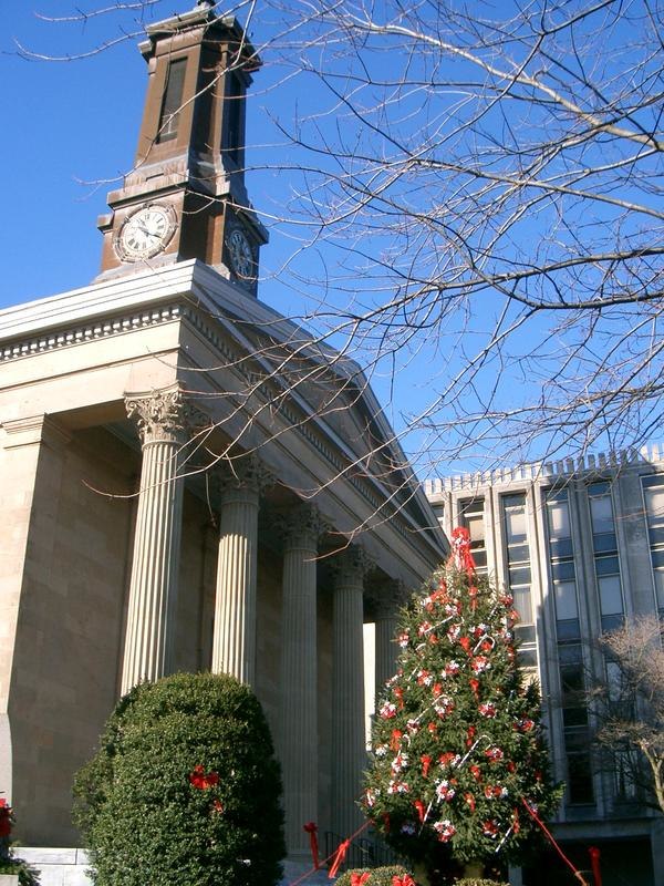
Photo: Zoewscott, Public domain.
The Chester County Courthouse is a historic courthouse building located in the county seat of West Chester, Chester County, Pennsylvania. It was built in 1846 at a cost of $55,346 and was designed by Thomas U. Chester County Courthouse is situated 3,200 feet north of New Street Parking Structure.
Farmers and Mechanics Building
Historic building

Photo: Smallbones, Public domain.
The Farmers and Mechanics Building is a historic "skyscraper" located in West Chester, Chester County, Pennsylvania. It was completed in 1908 and is a six-story skyscraper building, with a basement and penthouse in the Classical Revival style. Farmers and Mechanics Building is situated 3,100 feet north of New Street Parking Structure.
Places in the Area
Nearby places include West Chester and West Goshen.
West Chester

Photo: Smallbones, Public domain.
West Chester is a borough in Chester County in the Philadelphia Region of Pennsylvania. It is the county seat.
West Goshen
Village
West Goshen was a census-designated place in West Goshen Township, Chester County, Pennsylvania, United States. The population was 8,472 at the 2000 census. The CDP was not delineated for the 2010 census. West Goshen is situated 2 miles northeast of New Street Parking Structure.
Lenape
Hamlet
Lenape is an unincorporated community in Pocopson Township in Chester County, Pennsylvania, United States. Lenape is centered on the intersection of Pennsylvania Route 52 and Pocopson Road, west of the Brandywine Creek. Lenape is situated 3 miles southwest of New Street Parking Structure.
New Street Parking Structure
- Type: Parking area
- Parking: multi-storey
- Categories: building, parking garage, and transportation
- Location: Borough of West Chester, Chester County, Philadelphia Region, Pennsylvania, Mid-Atlantic, United States, North America
- View on OpenStreetMap
Latitude
39.95103° or 39° 57′ 4″ northLongitude
-75.60471° or 75° 36′ 17″ westOperator
West Chester UniversityOpen location code
87F6X92W+C4OpenStreetMap ID
way 543502211OpenStreetMap feature
amenity=parkingOpenStreetMap feature
building=parkingOpenStreetMap attribute
parking=multi-storey
This page is based on OpenStreetMap, Wikidata, and Wikimedia Commons.
We’d love your help improving our open data sources. Thank you for contributing.
Satellite Map
Discover New Street Parking Structure from above in high-definition satellite imagery.
Notable Places Nearby
Highlights include Kathy McBratnie Park and Calvary Lutheran Church.
Nearby Places
Explore places such as Lawrence Hall and Wayne Hall Parking Lot.
Chester County: Must-Visit Destinations
Delve into West Chester, Phoenixville, Downingtown, and Kennett Square.
Curious Parking Areas to Discover
Uncover intriguing parking areas from every corner of the globe.
About Mapcarta. Data © OpenStreetMap contributors and available under the Open Database License". Text is available under the CC BY-SA 4.0 license, except for photos, directions, and the map. Photo: Wikimedia, CC0.