Ostra-Ufer
Ostra-Ufer is a parking area in Dresden, Saxon Elbland, Saxony. Ostra-Ufer is situated nearby to Volksfestgelände Pieschener Allee, as well as near the stadium Heinz-Steyer-Stadion.| Tap on a place to explore it |
- Opening hours: 24/7
- Type: Parking area
- Parking: surface
Places of Interest Nearby
Highlights include Yenidze and Heinz-Steyer-Stadion.
Yenidze

Photo: Gürgi, Public domain.
Yenidze is a former cigarette factory building in Dresden, Saxony, Germany built between 1907 and 1909. Today it is used as an office building. It is notable for its Moorish Revival exterior design which borrows design elements from mosques and the Alhambra in Spain. Yenidze is situated 230 metres southwest of Ostra-Ufer.
Heinz-Steyer-Stadion
Stadium

Photo: SchiDD, CC BY-SA 4.0.
The Heinz-Steyer-Stadion, in Dresden, Germany, is an association football, American football and athletics stadium currently used by the Dresdner SC and the Dresden Monarchs. Heinz-Steyer-Stadion is situated 180 metres west of Ostra-Ufer.
Semperoper
Theater building
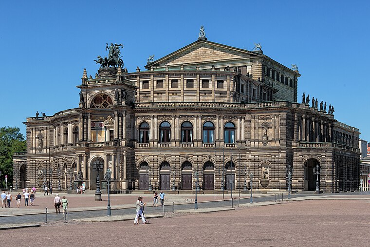
Photo: Avda, CC BY-SA 3.0.
The Semperoper is the opera house of the Sächsische Staatsoper Dresden and the concert hall of the Staatskapelle Dresden. It is also home to the Semperoper Ballett. Semperoper is situated 800 metres southeast of Ostra-Ufer.
Places in the Area
Nearby places include Ostravorwerk and Friedrichstadt.

Friedrichstadt
Suburb

Photo: X-Weinzar, CC BY-SA 3.0.
Friedrichstadt is a neighborhood in central Dresden, Germany. A factory district in the late 19th and early 20th centuries, it is known as the home of the founders of the artistic association known as Die Brücke. Its population is 9,887.

Ostra-Ufer
- Category: transportation
- Location: Dresden, Saxon Elbland, Saxony, Germany, Central Europe, Europe
- View on OpenStreetMap
Latitude
51.06048° or 51° 3′ 38″ northLongitude
13.72878° or 13° 43′ 44″ eastOperator
Landeshauptstadt DresdenOpen location code
9F3M3P6H+5GOpenStreetMap ID
way 564139997OpenStreetMap feature
amenity=parkingOpenStreetMap attribute
parking=surface
This page is based on OpenStreetMap, Wikidata, and Wikimedia Commons.
We’d love your help improving our open data sources. Thank you for contributing.
Satellite Map
Discover Ostra-Ufer from above in high-definition satellite imagery.
Notable Places Nearby
Highlights include Volksfestgelände Pieschener Allee and Marienbrücke II.
Nearby Places
Explore places such as Kletterskulptur and Kanalstützpunkt Weißeritzstraße.
Saxon Elbland: Must-Visit Destinations
Delve into Meißen, Riesa, Radebeul, and Freital.
Curious Parking Areas to Discover
Uncover intriguing parking areas from every corner of the globe.
About Mapcarta. Data © OpenStreetMap contributors and available under the Open Database License". Text is available under the CC BY-SA 4.0 license, except for photos, directions, and the map. Photo: Kreidefossil, CC BY-SA 3.0.