Quinta Cabeço da Moita
Quinta Cabeço da Moita is a farm in Leiria District, Portugal. Quinta Cabeço da Moita is situated nearby to Zona Húmida de São Gião, as well as near the nature reserve Monte de São Bartolomeu.| Tap on a place to explore it |
Places of Interest Nearby
Highlights include Monte de São Bartolomeu and Valado train station.
Monte de São Bartolomeu
Nature reserve

Photo: Vitor Oliveira, CC BY-SA 2.0.
Monte de São Bartolomeu is a nature reserve, which is situated 3 km north of Quinta Cabeço da Moita.
Valado train station
Railway station

Photo: Allankond, CC BY-SA 3.0.
Valado train station is a railway station, which is situated 3½ km northeast of Quinta Cabeço da Moita.
Igreja de São Gião
Church
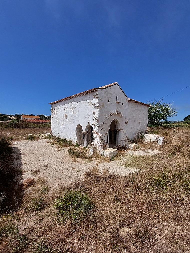
Photo: Threeohsix, CC BY-SA 4.0.
Igreja de São Gião is a medieval church in Famalicão, a parish of Nazaré, in the Oeste region of Portugal. It was discovered by Eduíno Borges Garcia in 1961 and is regarded as one of the oldest temples in Portugal and the Iberian Peninsula. Igreja de São Gião is situated 3 km west of Quinta Cabeço da Moita.
Places in the Area
Nearby places include Valado dos Frades and Cela.
Valado dos Frades
Town

Photo: Threeohsix, CC BY-SA 4.0.
Valado dos Frades is a Portuguese parish in the municipality of Nazaré. The population in 2011 was 3,109, in an area of 18.51 km². Valado dos Frades is situated 3½ km northeast of Quinta Cabeço da Moita.
Cela
Town
Cela is a freguesia in the municipality of Alcobaça, Portugal. The population in 2011 was 3,264, in an area of 25.83 km2. It received town status in 1999. Cela is situated 3½ km southeast of Quinta Cabeço da Moita.
Nazaré

Photo: Alvesgaspar, CC BY-SA 3.0.
Nazaré is a lovely village in the Oeste region of Portugal. It became a world famous surf spot and entered the Guinness Book of Records due to its gigantic waves. It is usually crowded in summer.
Quinta Cabeço da Moita
- Type: Farm
- Category: agriculture
- Location: Leiria District, Portugal, Iberia, Europe
- View on OpenStreetMap
Latitude
39.56737° or 39° 34′ 3″ northLongitude
-9.05242° or 9° 3′ 9″ westOpen location code
8CFGHW8X+W2OpenStreetMap ID
way 574108305OpenStreetMap feature
landuse=farmyard
This page is based on OpenStreetMap, Wikidata, and Wikimedia Commons.
We’d love your help improving our open data sources. Thank you for contributing.
Satellite Map
Discover Quinta Cabeço da Moita from above in high-definition satellite imagery.
Notable Places Nearby
Highlights include Quinta Nova and Antiga Estação Ferroviária de Cela.
Nearby Places
Explore places such as Quinta Cabeço da Moita and Meu Jardim.
Portugal: Must-Visit Destinations
Delve into Lisbon, Caldas da Rainha, Porto, and Coimbra.
Curious Farms to Discover
Uncover intriguing farms from every corner of the globe.
About Mapcarta. Data © OpenStreetMap contributors and available under the Open Database License". Text is available under the CC BY-SA 4.0 license, except for photos, directions, and the map. Photo: Tsy1980, CC BY-SA 4.0.