Santa Maria Port
Santa Maria Port is a station in Minato-ku, Osaka, Osaka. Santa Maria Port is situated nearby to the ticket shop Osaka Aquarium, as well as near Tempozan Harbor Village.| Tap on a place to explore it |
Places of Interest Nearby
Highlights include Osaka Culturarium at Tempozan and Osaka Aquarium.
Osaka Culturarium at Tempozan
Museum

Photo: hiromitsu morimoto, CC BY-SA 2.0.
Osaka Culturarium at Tempozan is a museum, which is situated 180 metres southeast of Santa Maria Port.
Osaka Aquarium
Ticket shop
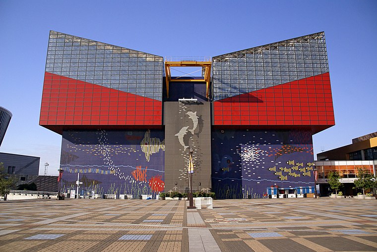
Photo: 663highland, CC BY 2.5.
The Osaka Aquarium Kaiyukan is an aquarium located in the ward of Minato in Osaka, Osaka Prefecture, Japan, near Osaka Bay. When it first opened, it was the largest public aquarium in the world.
Tempozan Ferris Wheel
Ferris wheel

Photo: 663highland, CC BY 2.5.
Tempozan Ferris Wheel is a 112-meter-tall Ferris wheel located in Osaka, Japan, at Tempozan Harbor Village, next to Osaka Aquarium Kaiyukan, one of the largest aquariums in the world. The wheel has a height of 112.5 metres and diameter of 100 metres. Tempozan Ferris Wheel is situated 280 metres northeast of Santa Maria Port.
Places in the Area
Nearby places include Universal Studios Japan and Konohana-ku.
Universal Studios Japan

Photo: Jpatokal, CC BY-SA 4.0.
Universal Studios Japan is a theme park located in Osaka, Japan. Opened on March 31, 2001, it is one of six Universal Studios theme parks worldwide and was the first to open outside the United States.
Konohana-ku
Suburb
 Konohana-ku is one of 24 wards of Osaka city, Japan. It stands at the mouth of the Yodo River. It is home to the popular western-style theme park of Universal Studios Japan. It will be the site of Expo 2025, a World's Fair to be held in 2025.
Taisho-ku
Suburb

Photo: KishujiRapid, CC BY-SA 4.0.
Taishō is one of 24 wards of Osaka, Japan. As of October 1, 2006, the ward has an estimated population of 72,742 and the total area is 9.43 km2. Taisho is surrounded by canals and it is named after the Taisho bridge, a main bridge built in Taishō period. Taisho-ku is situated 4 km east of Santa Maria Port.
Santa Maria Port
- Type: Station
- Categories: building, canopy, passenger ship terminal, and transportation
- Location: Minato-ku, Osaka, Osaka, Kansai, Japan, East Asia, Asia
- View on OpenStreetMap
Latitude
34.65505° or 34° 39′ 18″ northLongitude
135.4283° or 135° 25′ 42″ eastOpen location code
8Q6QMC4H+28OpenStreetMap ID
way 586887114OpenStreetMap feature
amenity=ferry_terminalOpenStreetMap feature
building=roofOpenStreetMap feature
public_transport=station
This page is based on OpenStreetMap, Wikidata, and Wikimedia Commons.
We’d love your help improving our open data sources. Thank you for contributing.
Satellite Map
Discover Santa Maria Port from above in high-definition satellite imagery.
In Other Languages
From Chinese to Korean—“Santa Maria Port” goes by many names.
- Chinese: “聖瑪麗亞號登船處”
- Korean: “산타마리아호”
Notable Places Nearby
Highlights include Tempozan Harbor Village and Legoland Discovery Center Osaka.
Nearby Places
Explore places such as Starbucks and The Little Mermaid.
Osaka: Must-Visit Destinations
Delve into Toyonaka, Osaka castle, Bay Area, and Minami.
Curious Stations to Discover
Uncover intriguing stations from every corner of the globe.
About Mapcarta. Data © OpenStreetMap contributors and available under the Open Database License". Text is available under the CC BY-SA 4.0 license, except for photos, directions, and the map. Photo: Kaiza96, CC BY-SA 3.0.