Cabane de la Montagne de Lau
Cabane de la Montagne de Lau is a shelter in Gresse-en-Vercors, Arrondissement of Grenoble, Auvergne-Rhône-Alpes and has an elevation of 1,750 metres. Cabane de la Montagne de Lau is situated nearby to the archaeological site Roman quarry, as well as near the peak Tête de la Graille.| Tap on a place to explore it |
Places of Interest Nearby
Highlights include Mont Aiguille.
Mont Aiguille
Peak
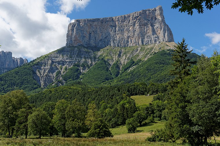
Photo: Jvillafruela, CC BY-SA 4.0.
Mont Aiguille is a mountain in the Vercors Massif of the French Prealps, located 58 km south of Grenoble, in the commune of Chichilianne, and the département of Isère. Mont Aiguille is situated 3½ km east of Cabane de la Montagne de Lau.
Places in the Area
Nearby places include Chichilianne and Saint-Michel-les-Portes.
Chichilianne
Village

Photo: Berrucomons, CC BY-SA 3.0.
Chichilianne is a commune in the Isère department in southeastern France. Chichilianne is situated 6 km southeast of Cabane de la Montagne de Lau.
Saint-Michel-les-Portes
Village

Photo: Wikimedia, Public domain.
Saint-Michel-les-Portes is a commune in the Isère department in southeastern France. Saint-Michel-les-Portes is situated 8 km northeast of Cabane de la Montagne de Lau.
Saint-Martin-de-Clelles
Village

Photo: Jvillafruela, CC BY-SA 3.0.
Saint-Martin-de-Clelles is a commune in the Isère department in southeastern France. Saint-Martin-de-Clelles is situated 9 km east of Cabane de la Montagne de Lau.
Cabane de la Montagne de Lau
- Type: Shelter
- Category: building
- Location: Gresse-en-Vercors, Arrondissement of Grenoble, Isère, Auvergne-Rhône-Alpes, France, Europe
- View on OpenStreetMap
Latitude
44.83426° or 44° 50′ 3″ northLongitude
5.50972° or 5° 30′ 35″ eastElevation
1,750 metres (5,741 feet)Open location code
8FP7RGM5+PVOpenStreetMap ID
way 601685591OpenStreetMap feature
amenity=shelterOpenStreetMap feature
building=yes
This page is based on OpenStreetMap, Wikidata, and Wikimedia Commons.
We’d love your help improving our open data sources. Thank you for contributing.
Satellite Map
Discover Cabane de la Montagne de Lau from above in high-definition satellite imagery.
Notable Places Nearby
Highlights include Roman quarry and Tête de la Graille.
Nearby Places
Explore places such as Bergerie de Peyre Rouge and Cabane de Montaveilla.
Isère: Must-Visit Destinations
Delve into Grenoble, Vienne, Voiron, and Alpe d’Huez.
Curious Shelters to Discover
Uncover intriguing shelters from every corner of the globe.
About Mapcarta. Data © OpenStreetMap contributors and available under the Open Database License". Text is available under the CC BY-SA 4.0 license, except for photos, directions, and the map. Photo: Samat, CC BY-SA 3.0.