Agencija Zdravilni dotik
Agencija Zdravilni dotik is a doctor’s office in Murska Sobota, Eastern Slovenia which is located on Gederovska ulica. Agencija Zdravilni dotik is situated nearby to the meadow Pašnik, as well as near the village Černelavci.| Tap on a place to explore it |
Places of Interest Nearby
Highlights include Fazanerija City Stadium and Pomurje Museum Murska Sobota.
Fazanerija City Stadium
Stadium
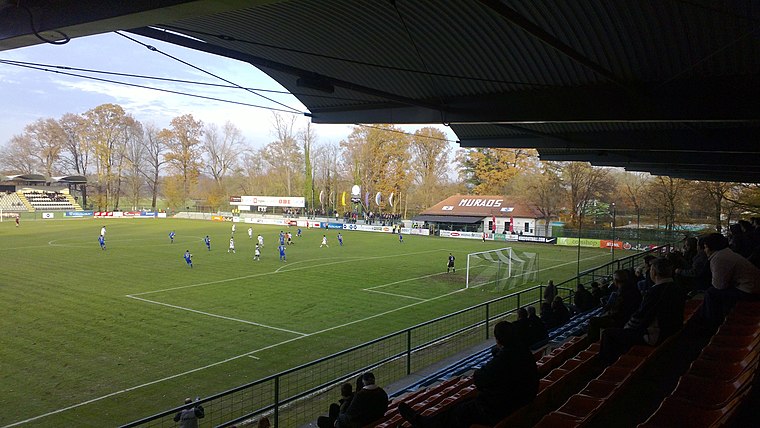 Fazanerija City Stadium is a multi-use stadium in Murska Sobota, Slovenia. It is currently used mostly for football matches and is the home ground of NŠ Mura. Fazanerija City Stadium is situated 1¼ km northeast of Agencija Zdravilni dotik.
Pomurje Museum Murska Sobota
Museum

Photo: János Korom Dr., CC BY-SA 2.0.
Pomurje Museum Murska Sobota is situated 1½ km east of Agencija Zdravilni dotik.
Murska Sobota City Park
Park

Photo: Nadaja, CC BY-SA 4.0.
Murska Sobota City Park is situated 1½ km east of Agencija Zdravilni dotik.
Places in the Area
Nearby places include Černelavci and Veščica.
Černelavci
Village

Photo: DoncseczII, CC BY-SA 4.0.
Černelavci is a village in the Municipality of Murska Sobota in the Prekmurje region of northeastern Slovenia. The writer György Czipott was born here.
Veščica
Village

Photo: Lanfra, CC BY-SA 3.0.
Veščica or Veščica pri Murski Soboti is a village in the Municipality of Murska Sobota in the Prekmurje region of Slovenia.
Pušča
Village
Pušča is a village in the Municipality of Murska Sobota in the Prekmurje region of northeastern Slovenia. It is a Romani village.
Agencija Zdravilni dotik
- Type: Doctor’s office
- Address: Gederovska ulica 14, Černelavci, 9000
- Categories: health care and building
- Location: Murska Sobota, Eastern Slovenia, Slovenia, Central Europe, Europe
- View on OpenStreetMap
Latitude
46.6638° or 46° 39′ 50″ northLongitude
16.14159° or 16° 8′ 30″ eastOpen location code
8FRRM47R+GJOpenStreetMap ID
way 627501855OpenStreetMap feature
amenity=doctorsOpenStreetMap feature
building=yesOpenStreetMap feature
healthcare=doctor
This page is based on OpenStreetMap, Wikidata, and Wikimedia Commons.
We’d love your help improving our open data sources. Thank you for contributing.
Satellite Map
Discover Agencija Zdravilni dotik from above in high-definition satellite imagery.
Notable Places Nearby
Highlights include Pašnik and TC Maximus.
Nearby Places
Explore places such as Černelavci Liškova and Barbie.
Eastern Slovenia: Must-Visit Destinations
Delve into Maribor, Ptuj, Lendava, and Goričko Landscape Park.
Curious Doctor’s Offices to Discover
Uncover intriguing doctor’s offices from every corner of the globe.
About Mapcarta. Data © OpenStreetMap contributors and available under the Open Database License". Text is available under the CC BY-SA 4.0 license, except for photos, directions, and the map. Photo: Wikimedia, CC0.