Boston Harbor Yacht Club
Boston Harbor Yacht Club is a marina in City of Boston, Suffolk, Massachusetts. Boston Harbor Yacht Club is situated nearby to the marina Columbia Yacht Club, as well as near South Boston Yacht Club.| Tap on a place to explore it |
Places of Interest Nearby
Highlights include John F. Kennedy Presidential Library and Museum and City Point Bus Terminal.
John F. Kennedy Presidential Library and Museum
Museum

Photo: Fcb981, CC BY-SA 3.0.
The John F. Kennedy Presidential Library and Museum is the presidential library and museum of John F. Kennedy, the 35th president of the United States. John F. Kennedy Presidential Library and Museum is situated 1 mile south of Boston Harbor Yacht Club.
City Point Bus Terminal
Bus station

Photo: Pi.1415926535, CC BY-SA 3.0.
City Point Bus Terminal is a bus station in South Boston, Massachusetts. It serves MBTA bus routes 7, 9, 10 and 11. From 2004 to 2009, it was the terminus of Silver Line route SL3. City Point Bus Terminal is situated 2,600 feet north of Boston Harbor Yacht Club.
Calf Pasture Pumping Station Complex
Historic building
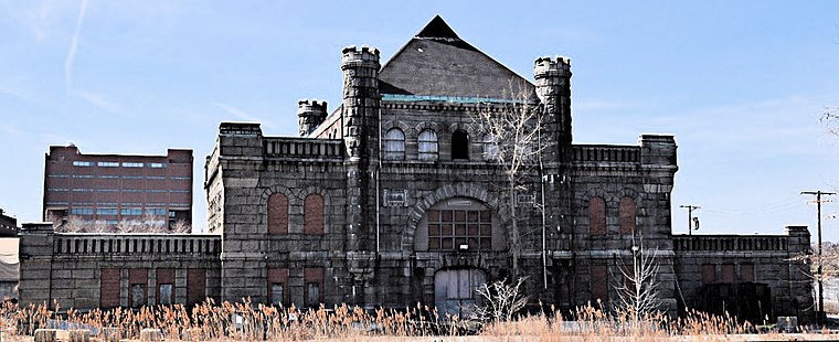
Photo: Magicpiano, CC BY-SA 4.0.
The Calf Pasture Pumping Station Complex is a historic sewage treatment facility at 435 Mount Vernon Street on Columbia Point in the Dorchester section of Boston, Massachusetts which was built in the 1880s. Calf Pasture Pumping Station Complex is situated 1¼ miles southwest of Boston Harbor Yacht Club.
Places in the Area
Nearby places include Dorchester Heights and South Boston.
Dorchester Heights
Neighborhood

Photo: Jameslwoodward, CC BY-SA 3.0.
Dorchester Heights is the central area of South Boston. It is the highest area in the neighborhood and commands a view of both Boston Harbor and downtown.
South Boston

Photo: Dale Cruse, CC BY 2.0.
Honor. Tradition. Loyalty. If you're familiar with South Boston as presented on the silver screen, these values might spring foremost to your mind. You wouldn't be wrong, but a lot has changed since mob boss Whitey Bulger controlled his criminal underworld from here during the 1970s.
South Bay Interchange
Locality

Photo: Wikimedia, CC BY-SA 2.5.
The South Bay Interchange is a massive interchange in downtown Boston, Massachusetts, in the US. The interchange consists of Interstate 90, the Mass Pike Extension, and the Interstate 93 concurrency with US 1 and MA 3 south of the Thomas P. South Bay Interchange is situated 2 miles northwest of Boston Harbor Yacht Club.
Boston Harbor Yacht Club
- Type: Marina
- Categories: recreation area and transportation
- Location: City of Boston, Suffolk, Massachusetts, New England, United States, North America
- View on OpenStreetMap
Latitude
42.33162° or 42° 19′ 54″ northLongitude
-71.02843° or 71° 1′ 42″ westOpen location code
87JC8XJC+JJOpenStreetMap ID
way 638275318OpenStreetMap feature
leisure=marina
This page is based on OpenStreetMap, Wikidata, and Wikimedia Commons.
We’d love your help improving our open data sources. Thank you for contributing.
Satellite Map
Discover Boston Harbor Yacht Club from above in high-definition satellite imagery.
Notable Places Nearby
Highlights include Columbia Yacht Club and South Boston Yacht Club.
Nearby Places
Explore places such as Columbia Rd @ O St and E 8th @ Columbia Rd.
Massachusetts: Must-Visit Destinations
Delve into Boston, Cambridge, Springfield, and Downtown Boston.
Curious Marinas to Discover
Uncover intriguing marinas from every corner of the globe.
About Mapcarta. Data © OpenStreetMap contributors and available under the Open Database License". Text is available under the CC BY-SA 4.0 license, except for photos, directions, and the map. Photo: papadunes, CC BY-SA 3.0.