Gendarmerie - Brigade d’Étretat
Gendarmerie - Brigade d’Étretat is a police station in Étretat, Arrondissement of Le Havre, Normandy. Gendarmerie - Brigade d’Étretat is situated nearby to the railway station Vélo-Rails Étretat Pays de Caux, as well as near the church Église Notre-Dame d’Étretat.| Tap on a place to explore it |
- Opening hours:
Monday: 8:00 AM—noon and 2:00 PM—6:00 PM
Wednesday: 8:00 AM—noon and 2:00 PM—6:00 PM
Saturday: 8:00 AM—noon and 2:00 PM—6:00 PM - Type: Police station
- Description: unité de gendarmerie
- Also known as: “Gendarmerie nationale”
- Address: Étretat, 76790
Places of Interest Nearby
Highlights include Château des Aygues and Église Notre-Dame d’Étretat.
Château des Aygues
Castle

Photo: Wikimedia, CC BY-SA 2.5.
Château des Aygues is a castle, which is situated 470 metres southwest of Gendarmerie - Brigade d’Étretat.
Église Notre-Dame d’Étretat
Church

Photo: ThruTheseLines, CC BY 2.0.
Église Notre-Dame d’Étretat is a church, which is situated 420 metres west of Gendarmerie - Brigade d’Étretat.
Le Clos Arsène Lupin, Maison Maurice Leblanc
Museum
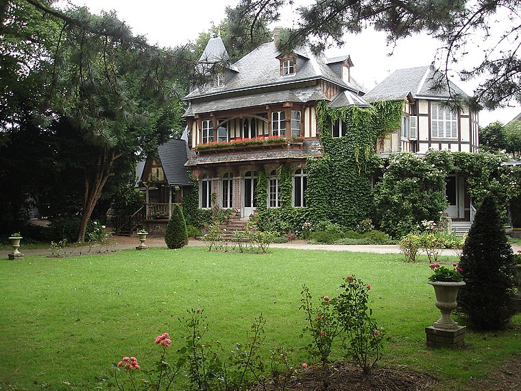
Photo: Wikimedia, CC BY-SA 2.5.
Le Clos Arsène Lupin, Maison Maurice Leblanc is a museum dedicated to the fictional hero Arsène Lupin, created by the writer Maurice Leblanc. The museum is located at 15, rue Guy-de-Maupassant in Étretat, in the former home of Maurice Leblanc. Le Clos Arsène Lupin, Maison Maurice Leblanc is situated 770 metres west of Gendarmerie - Brigade d’Étretat.
Places in the Area
Nearby places include Beaurepaire and Anglesqueville-l’Esneval.
Beaurepaire
Village

Photo: touzainphilippe, CC BY 3.0.
Beaurepaire is a commune in the Seine-Maritime department in the Normandy region in northern France. Beaurepaire is situated 5 km south of Gendarmerie - Brigade d’Étretat.
Anglesqueville-l’Esneval
Village

Photo: Havang(nl), CC0.
Anglesqueville-l’Esneval is a commune in the Seine-Maritime department in the Normandy region in northern France. Anglesqueville-l’Esneval is situated 9 km south of Gendarmerie - Brigade d’Étretat.
Gendarmerie - Brigade d’Étretat
- Categories: Gendarmerie barracks and building
- Location: Étretat, Arrondissement of Le Havre, Seine-Maritime, Normandy, France, Europe
- View on OpenStreetMap
Latitude
49.70876° or 49° 42′ 32″ northLongitude
0.21686° or 0° 13′ 1″ eastOperator
National GendarmerieOpen location code
8FX2P658+GPOpenStreetMap ID
way 639119187OpenStreetMap feature
amenity=policeOpenStreetMap feature
building=yesWikidata ID
Q77859387
This page is based on OpenStreetMap, Wikidata, and Wikimedia Commons.
We’d love your help improving our open data sources. Thank you for contributing.
Satellite Map
Discover Gendarmerie - Brigade d’Étretat from above in high-definition satellite imagery.
In Other Languages
“Gendarmerie - Brigade d’Étretat” goes by many names.
- French: “brigade de gendarmerie d’Étretat”
- French: “Brigade de gendarmerie d’Étretat”
Notable Places Nearby
Highlights include Vélo-Rails Étretat Pays de Caux and Salle Adolphe Boissaye.
Nearby Places
Explore places such as Parking de la Gare and Gare (Étretat).
Normandy: Must-Visit Destinations
Delve into Orne, Rouen, Seine-Maritime, and Le Havre.
Curious Police Stations to Discover
Uncover intriguing police stations from every corner of the globe.
About Mapcarta. Data © OpenStreetMap contributors and available under the Open Database License". Text is available under the CC BY-SA 4.0 license, except for photos, directions, and the map. Photo: Tim Geers, CC BY-SA 2.0.