Rotco
Rotco is a driving school in Paramaribo District, Suriname which is located on Kwattaweg. Rotco is situated nearby to the church Sint Alfonsuskerk, Paramaribo, as well as near New Generation Gods Trumpet / Nieuwe Generatie Godsbazuin.| Tap on a place to explore it |
Places of Interest Nearby
Highlights include Sint Alfonsuskerk, Paramaribo and Embassy of India.
Sint Alfonsuskerk, Paramaribo
Church

Photo: Otter, CC BY-SA 4.0.
Sint Alfonsuskerk, Paramaribo is a church, which is situated 340 metres southeast of Rotco.
Embassy of India
Government office

Photo: Ymnes, CC BY-SA 4.0.
Embassy of India is a government office, which is situated 720 metres southwest of Rotco.
André Kamperveen Stadion
Stadium
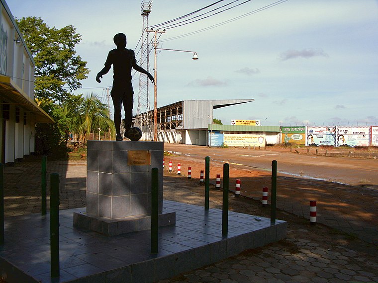
Photo: Brokopondo, Public domain.
André Kamperveen Stadium, formerly the National Stadion, is a multi-purpose stadium in Paramaribo, Suriname. Since its opening in 1953, the stadium has been the official home stadium of both football teams S.V. André Kamperveen Stadion is situated 1¼ km east of Rotco.
Places in the Area
Nearby places include Paramaribo and Beekhuizen.
Paramaribo

Photo: Sn.fernandez, CC BY-SA 4.0.
Paramaribo, often called Par'bo, is the lively capital and only city of the sparsely inhabited country of Suriname. Home to about 240,000 people, or over half of the country's population, this laid-back South American gem lies 15 km from the Atlantic Ocean.
Beekhuizen
Village

Photo: Wikimedia, CC BY-SA 4.0.
Beekhuizen is a former sugarcane plantation and currently a resort in Suriname, located in the Paramaribo District. Its population at the 2012 census was 17,185. Beekhuizen is situated 3½ km south of Rotco.
Flora
Village
Flora is a resort in Suriname, located in the Paramaribo District. Its population at the 2012 census was 19,538. Flora is both the name of the resort and the neighbourhood within the resort. Flora is situated 3½ km southwest of Rotco.
Rotco
- Type: Driving school
- Address: 68 Kwattaweg, Paramaribo
- Categories: building and transportation
- Location: Paramaribo District, Suriname, South America
- View on OpenStreetMap
Latitude
5.83683° or 5° 50′ 13″ northLongitude
-55.17258° or 55° 10′ 21″ westOpen location code
68Q6RRPG+PXOpenStreetMap ID
way 642034891OpenStreetMap feature
amenity=driving_schoolOpenStreetMap feature
building=yes
This page is based on OpenStreetMap, Wikidata, and Wikimedia Commons.
We’d love your help improving our open data sources. Thank you for contributing.
Satellite Map
Discover Rotco from above in high-definition satellite imagery.
Notable Places Nearby
Highlights include New Generation Gods Trumpet / Nieuwe Generatie Godsbazuin and Marius Rust.
Nearby Places
Explore places such as Jong A Kiem Meelproduktenfabriek and Sami’s Podosiri.
Suriname: Must-Visit Destinations
Delve into Paramaribo, Surinamese Rainforest, East Coast, and West Coast.
Curious Driving Schools to Discover
Uncover intriguing driving schools from every corner of the globe.
About Mapcarta. Data © OpenStreetMap contributors and available under the Open Database License". Text is available under the CC BY-SA 4.0 license, except for photos, directions, and the map. Photo: S23678, CC BY-SA 3.0.