Diakoniewerk München-Maxvorstadt
Diakoniewerk München-Maxvorstadt is a hospital in Munich, Upper Bavaria, Bavaria which is located on Heßstraße. Diakoniewerk München-Maxvorstadt is situated nearby to the work of art Sockelobjekt, as well as near SalsaMás.| Tap on a place to explore it |
- Email: service@diakoniewerk-muenchen.de
- Type: Hospital
- Also known as: “Diakoniewerk München-Maxvorstadt Körperschaft des öffentlichen Rechts”
- Address: Heßstraße 22, München, 80799
- Wheelchair access: yes
Places of Interest Nearby
Highlights include Alte Pinakothek and Pinakothek der Moderne.
Alte Pinakothek
Museum

Photo: Wikimedia, CC BY-SA 3.0.
The Alte Pinakothek is an art museum located in the Kunstareal area in Munich, Germany. It is one of the oldest galleries in the world and houses a significant collection of Old Master paintings. Alte Pinakothek is situated 340 metres south of Diakoniewerk München-Maxvorstadt.
Pinakothek der Moderne
Museum
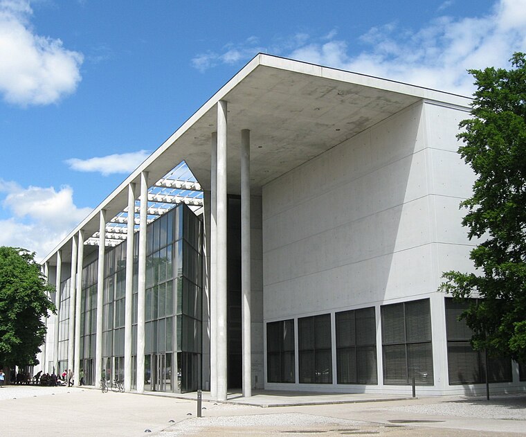
Photo: Rufus46, CC BY-SA 3.0.
The Pinakothek der Moderne is a modern art museum, situated in central Munich's Kunstareal. Pinakothek der Moderne is situated 510 metres southeast of Diakoniewerk München-Maxvorstadt.
Museum Brandhorst
Museum

Photo: Wikimedia, CC BY-SA 4.0.
The Brandhorst Museum was opened in Munich on 21 May 2009. It displays about 200 exhibits from the modern art collection of the heirs of the Henkel trust Udo and Anette Brandhorst. In 2009 the Brandhorst Collection comprises more than 700 works. Museum Brandhorst is situated 500 metres southeast of Diakoniewerk München-Maxvorstadt.
Places in the Area
Nearby places include Maxvorstadt and St.-Benno-Viertel.
Maxvorstadt

Photo: Tbp386, CC BY-SA 3.0.
Maxvorstadt is the arts and university district of Munich, just north of Altstadt the historic city centre.

Diakoniewerk München-Maxvorstadt
- Category: health care
- Location: Munich, Upper Bavaria, Bavaria, Germany, Central Europe, Europe
- View on OpenStreetMap
Latitude
48.15135° or 48° 9′ 5″ northLongitude
11.56938° or 11° 34′ 10″ eastOpen location code
8FWH5H29+GQOpenStreetMap ID
way 646923786OpenStreetMap feature
amenity=hospitalOpenStreetMap feature
healthcare=hospitalOpenStreetMap attribute
wheelchair=yes
This page is based on OpenStreetMap, Wikidata, and Wikimedia Commons.
We’d love your help improving our open data sources. Thank you for contributing.
Satellite Map
Discover Diakoniewerk München-Maxvorstadt from above in high-definition satellite imagery.
Notable Places Nearby
Highlights include Sockelobjekt and SalsaMás.
Nearby Places
Explore places such as Haus 1 and Algesiologikum MVZ.
Munich: Must-Visit Destinations
Delve into North Munich, Altstadt, Haidhausen, and Ludwigsvorstadt-Isarvorstadt.
Curious Places to Discover
Uncover intriguing places from every corner of the globe.
About Mapcarta. Data © OpenStreetMap contributors and available under the Open Database License". Text is available under the CC BY-SA 4.0 license, except for photos, directions, and the map. Photo: Heav84, CC BY-SA 3.0.