Myers Apartments
Myers Apartments is an apartment building in Borough of Newport, Perry County, Pennsylvania which is located on North 2nd Street. Myers Apartments is situated nearby to the village Newport, as well as near the health club King’s Fitness.| Tap on a place to explore it |
Places of Interest Nearby
Highlights include Fleisher Covered Bridge.
Fleisher Covered Bridge
Bridge
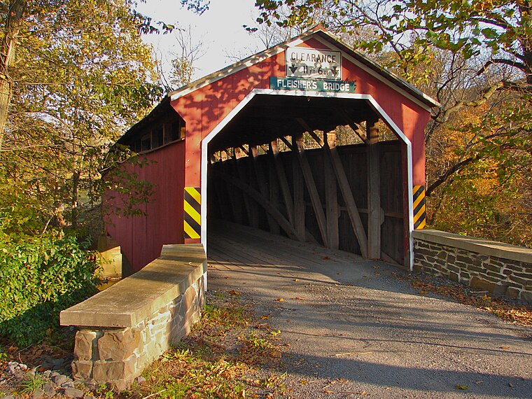
Photo: Smallbones, Public domain.
The Fleisher Covered Bridge, also known as Fleisher's Covered Bridge, is an historic wooden covered bridge located in Oliver Township, near the community of Newport in Perry County, Pennsylvania. It was built as a single-span bridge in 1887. Fleisher Covered Bridge is situated 1½ miles northwest of Myers Apartments.
Places in the Area
Nearby places include Newport and New Bloomfield.
Newport
Village
Photo: Doug Kerr, CC BY-SA 2.0.
Newport is a borough in Perry County, Pennsylvania, United States. The population was 1,487 at the 2020 census. It is part of the Harrisburg–Carlisle Metropolitan Statistical Area.
New Bloomfield
Village

Photo: Smallbones, Public domain.
Bloomfield, commonly known as New Bloomfield, is a borough in, and the county seat of, Perry County, Pennsylvania, United States. It is part of the Harrisburg–Carlisle metropolitan statistical area. The population was 1,244 at the 2020 census. New Bloomfield is situated 5 miles southwest of Myers Apartments.
Myers Apartments
- Type: Apartment building
- Address: 29 North 2nd Street, Newport, PA 17074
- Categories: building and residential building
- Location: Borough of Newport, Perry County, Pennsylvania, Mid-Atlantic, United States, North America
- View on OpenStreetMap
Latitude
40.47821° or 40° 28′ 42″ northLongitude
-77.13125° or 77° 7′ 53″ westLevels
3Open location code
87G4FVH9+7FOpenStreetMap ID
way 652569191OpenStreetMap feature
building=apartments
This page is based on OpenStreetMap, Wikidata, and Wikimedia Commons.
We’d love your help improving our open data sources. Thank you for contributing.
Satellite Map
Discover Myers Apartments from above in high-definition satellite imagery.
Places with the Same Name
Discover other places named “Myers Apartments”.
Notable Places Nearby
Highlights include King’s Fitness and Perry County Council of the Arts.
Nearby Places
Explore places such as Goodwill and The Jewel Box.
Pennsylvania: Must-Visit Destinations
Delve into Philadelphia, Pittsburgh, Harrisburg, and Scranton.
Curious Apartment Buildings to Discover
Uncover intriguing apartment buildings from every corner of the globe.
About Mapcarta. Data © OpenStreetMap contributors and available under the Open Database License". Text is available under the CC BY-SA 4.0 license, except for photos, directions, and the map. Photo: Nicholas A. Tonelli, CC BY 2.0.