Gendarmerie nationale
Gendarmerie nationale is a police station in Cysoing, Arrondissement of Lille, Hauts-de-France which is located on Rue Jean-Baptiste Lebas. Gendarmerie nationale is situated nearby to the sports venue Complexe sportif Jean Tiquet, as well as near the fire station Centre d’incendie et de secours de Cysoing.| Tap on a place to explore it |
- Opening hours:
Monday—Saturday: 8:00 AM—noon and 2:00 PM—6:00 PM
Sunday: 9:00 AM—noon and 3:00 PM—6:00 PM
public holidays: 9:00 AM—noon and 3:00 PM—6:00 PM - Email: bta.cysoing@gendarmerie.interieur.gouv.fr
- Type: Police station
- Also known as: “Gendarmerie - Brigade de Cysoing”
- Address: Rue Jean-Baptiste Lebas 1159, Cysoing, 59830
- Wheelchair access: yes
Places of Interest Nearby
Highlights include Chapelle Saint-Léonard de Bouvines and Chapelle Saint-Hubert de Bouvines.
Chapelle Saint-Léonard de Bouvines
Church

Photo: Codepem, CC BY-SA 3.0.
Chapelle Saint-Léonard de Bouvines is a church, which is situated 1 km west of Gendarmerie nationale.
Chapelle Saint-Hubert de Bouvines
Church

Photo: Ottaviani, CC BY-SA 3.0.
Chapelle Saint-Hubert de Bouvines is a church, which is situated 1 km northwest of Gendarmerie nationale.
Église Saint-Calixte-Saint-Évrard
Church

Photo: Codepem, CC BY-SA 3.0.
Église Saint-Calixte-Saint-Évrard is a church, which is situated 1 km southeast of Gendarmerie nationale.
Places in the Area
Nearby places include Carrefour de l’Arbre and Haute Borne.
Carrefour de l’Arbre
Locality
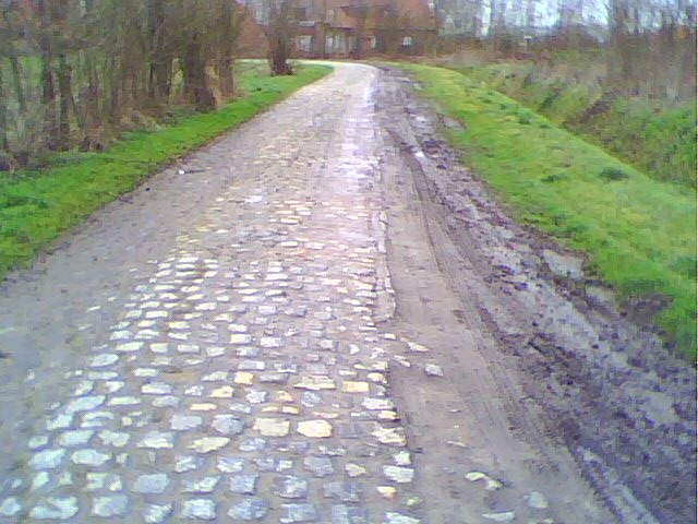
Photo: Wikimedia, CC BY-SA 3.0.
Carrefour de l'Arbre, officially Pavé de Luchin, is a 2.1 km cobbled road in the municipalities of Camphin-en-Pévèle, Baisieux-Sin and Gruson, in the Nord department of Northern France. Carrefour de l’Arbre is situated 2½ km northeast of Gendarmerie nationale.
Haute Borne
Suburb

Photo: Jiel, CC BY-SA 3.0.
Haute Borne is a new district of Villeneuve d'Ascq city, in France. It hosts the Haute Borne European scientific park. The aim of this area is to be home from high-tech companies and research and development centers, which can take advantage of laboratories and researchers of the University of Lille close to Haute Borne. Haute Borne is situated 5 km northwest of Gendarmerie nationale.
Templeuve-en-Pévèle
Village

Photo: Kaelkael, CC BY-SA 3.0.
Templeuve-en-Pévèle is a commune in the Nord department in northern France. Templeuve-en-Pévèle is situated 5 km southwest of Gendarmerie nationale.
Gendarmerie nationale
- Category: building
- Location: Cysoing, Arrondissement of Lille, North, Hauts-de-France, France, Europe
- View on OpenStreetMap
Latitude
50.5734° or 50° 34′ 24″ northLongitude
3.20191° or 3° 12′ 7″ eastOperator
National GendarmerieOpen location code
9F25H6F2+9QOpenStreetMap ID
way 654073632OpenStreetMap feature
amenity=policeOpenStreetMap feature
building=yesOpenStreetMap attribute
wheelchair=yes
This page is based on OpenStreetMap, Wikidata, and Wikimedia Commons.
We’d love your help improving our open data sources. Thank you for contributing.
Satellite Map
Discover Gendarmerie nationale from above in high-definition satellite imagery.
Places with the Same Name
Discover other places named “Gendarmerie nationale”.
Notable Places Nearby
Highlights include Complexe sportif Jean Tiquet and Centre d’incendie et de secours de Cysoing.
Nearby Places
Explore places such as Opticien Vision Plus Bouvines and Rika le poêle.
Hauts-de-France: Must-Visit Destinations
Delve into Lille, Dunkirk, Calais, and Amiens.
Curious Police Stations to Discover
Uncover intriguing police stations from every corner of the globe.
About Mapcarta. Data © OpenStreetMap contributors and available under the Open Database License". Text is available under the CC BY-SA 4.0 license, except for photos, directions, and the map. Photo: LimoWreck, CC BY-SA 3.0.