Le Prieuré Boutefol
Le Prieuré Boutefol is a guest house in Surville, Arrondissement of Lisieux, Normandy which is located on Route de Rouen. Le Prieuré Boutefol is situated nearby to the police station Gendarmerie - Brigade de Pont-l’Évêque, as well as near the military installation Brigade de proximité et peloton motorisé de Pont-L’Évêque.| Tap on a place to explore it |
- Email: info@prieureboutefol.com
- Type: Guest house
- Address: 313 Route de Rouen, Surville, 14130
Places of Interest Nearby
Highlights include Pont-l’Évêque station and Église Saint-Martin de Surville.
Pont-l’Évêque station
Railway station

Photo: Captain Scarlet, CC BY 2.5.
Gare de Pont-l'Évêque is a railway station serving the town Pont-l'Évêque, arrondissement of Lisieux, Calvados department, Normandy, France. Pont-l’Évêque station is situated 1¼ km southwest of Le Prieuré Boutefol.
Église Saint-Martin de Surville
Church

Photo: ArséniureDeGallium, CC BY-SA 3.0.
Église Saint-Martin de Surville is a church, which is situated 1 km northeast of Le Prieuré Boutefol.
Église Saint-Melaine
Church

Photo: EdouardHue, CC BY-SA 3.0.
Église Saint-Melaine is a church, which is situated 1 km southwest of Le Prieuré Boutefol.
Places in the Area
Nearby places include Coudray-Rabut and Pont-l’Évêque.
Coudray-Rabut
Village

Photo: Pymouss, CC BY-SA 3.0.
Coudray-Rabut is a former commune in the Calvados department in the Normandy region in northwestern France. On 1 January 2019, it was merged into the commune Pont-l'Évêque.
Pont-l’Évêque
Village

Photo: Nitot, CC BY-SA 3.0.
Pont-l'Évêque is a commune in the Calvados department in the Normandy region in northwestern France. It is known for Pont-l'Évêque cheese, a type of soft cheese, the oldest Normandy cheese in production.
Saint-Julien-sur-Calonne
Village
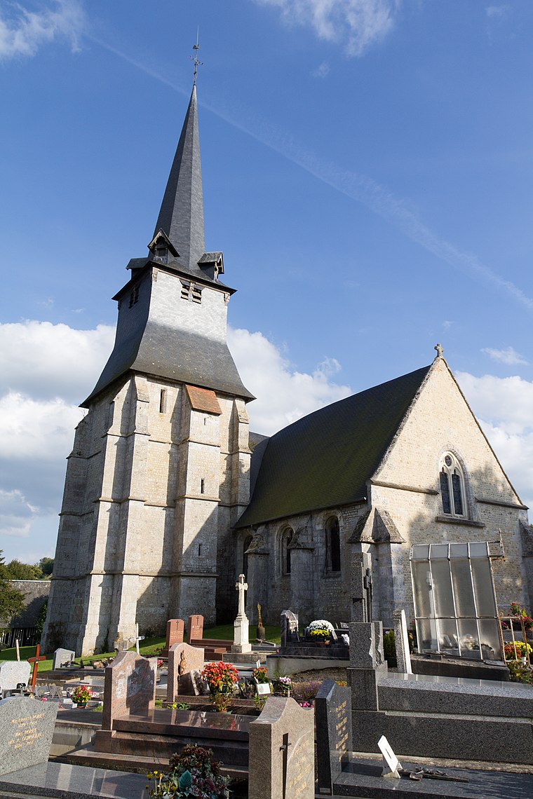
Photo: EdouardHue, CC BY-SA 3.0.
Saint-Julien-sur-Calonne is a commune in the Calvados department in the Normandy region in northwestern France.
Le Prieuré Boutefol
- Categories: building, tourism, and accommodation
- Location: Surville, Arrondissement of Lisieux, Calvados, Normandy, France, Europe
- View on OpenStreetMap
Latitude
49.2969° or 49° 17′ 49″ northLongitude
0.20136° or 0° 12′ 5″ eastOpen location code
8FX276W2+QGOpenStreetMap ID
way 660899658OpenStreetMap feature
building=yesOpenStreetMap feature
tourism=guest_house
This page is based on OpenStreetMap, Wikidata, and Wikimedia Commons.
We’d love your help improving our open data sources. Thank you for contributing.
Satellite Map
Discover Le Prieuré Boutefol from above in high-definition satellite imagery.
Notable Places Nearby
Highlights include Gendarmerie - Brigade de Pont-l’Évêque and Brigade de proximité et peloton motorisé de Pont-L’Évêque.
Nearby Places
Explore places such as Le Vieux Pressoir and Auberge Saint-Martin.
Normandy: Must-Visit Destinations
Delve into Orne, Rouen, Seine-Maritime, and Le Havre.
Curious Guest Houses to Discover
Uncover intriguing guest houses from every corner of the globe.
About Mapcarta. Data © OpenStreetMap contributors and available under the Open Database License". Text is available under the CC BY-SA 4.0 license, except for photos, directions, and the map. Photo: Inkey, CC BY-SA 3.0.