Naval Weapons Industrial Reserve Plant, Bedford
Naval Weapons Industrial Reserve Plant, Bedford was a government-owned, contractor-operated facility which had the mission of designing, fabricating, and testing prototype weapons and equipment from 1952 until December 2000, located in Bedford, Massachusetts It is located just north of Hanscom Air Force Base.| Tap on a place to explore it |
Places of Interest Nearby
Highlights include Lawrence G. Hanscom Field and First Parish Meetinghouse.
Lawrence G. Hanscom Field
Aerodrome
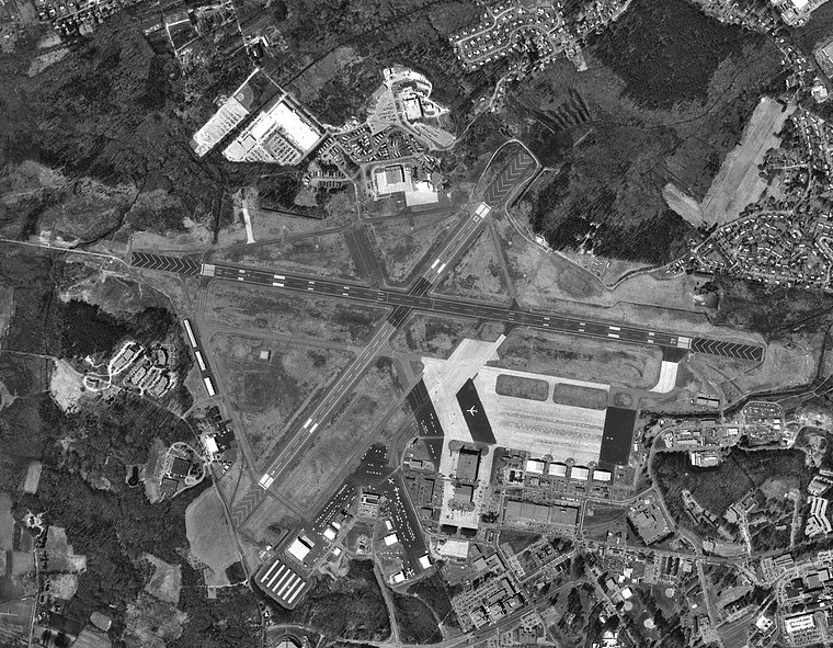
Photo: USGS, Public domain.
Laurence G. Hanscom Field, commonly known as Hanscom Field, is a public use airport operated by the Massachusetts Port Authority, located 14 mi outside Boston in Bedford, Massachusetts, United States.
First Parish Meetinghouse
Place of worship
 First Parish Meetinghouse is a place of worship, which is situated 1 mile northeast of Naval Weapons Industrial Reserve Plant, Bedford.
Bedford Center Historic District
Protected area

Photo: Daderot, CC BY-SA 3.0.
The Bedford Center Historic District encompasses the historic heart of the town of Bedford, Massachusetts. It extends along Great Road between Bacon and Concord Roads, and includes primarily residential areas on adjacent side streets.
Places in the Area
Nearby places include Bedford and Concord.
Bedford
 Bedford is a town in Massachusetts with a population of 14,000. Carlisle is a town with a population of 5,000. A low population density gives the town a rural feel, and it's known for outdoor activities including hiking and biking.
Concord
 Maybe you’ve never heard of sleepy Concord Massachusetts population 18,000, but your life has certainly been impacted by it. This is where "the shot heard round the world" was fired in the spring of 1775, setting off a chain of events that would eventually lead to the creation of the United States.
Lincoln
Village

Photo: Daderot, CC BY-SA 3.0.
Maybe you’ve never heard of sleepy Concord Massachusetts population 18,000, but your life has certainly been impacted by it. This is where "the shot heard round the world" was fired in the spring of 1775, setting off a chain of events that would eventually lead to the creation of the United States. Lincoln is situated 3½ miles south of Naval Weapons Industrial Reserve Plant, Bedford.
Naval Weapons Industrial Reserve Plant, Bedford
- Type: Brownfield land
- Also known as: “Bedford Naval Weapons Industrial Reserve Plant”
- Categories: military installation and industry
- Location: Town of Bedford, Middlesex, Massachusetts, New England, United States, North America
- View on OpenStreetMap
Latitude
42.47832° or 42° 28′ 42″ northLongitude
-71.2893° or 71° 17′ 22″ westOpen location code
87JCFPH6+87OpenStreetMap ID
way 68651882OpenStreetMap feature
landuse=brownfieldWikidata ID
Q4879171
This page is based on OpenStreetMap, Wikidata, Wikimedia Commons, and Wikipedia.
We’d love your help improving our open data sources. Thank you for contributing.
Satellite Map
Discover Naval Weapons Industrial Reserve Plant, Bedford from above in high-definition satellite imagery.
Notable Places Nearby
Highlights include Hartwells Hill and Edge Sports Center.
Nearby Places
Explore places such as Hartwell Town Forest Parking and Instrumentation Labs.
Massachusetts: Must-Visit Destinations
Delve into Boston, Cambridge, Springfield, and Downtown Boston.
Curious Places to Discover
Uncover intriguing places from every corner of the globe.
About Mapcarta. Data © OpenStreetMap contributors and available under the Open Database License". Text is available under the CC BY-SA 4.0 license, except for photos, directions, and the map. Description text is based on the Wikipedia page “Naval Weapons Industrial Reserve Plant, Bedford”. Photo: papadunes, CC BY-SA 3.0.