School gym building
School gym building is a school building in Varna, Bulgaria. School gym building is situated nearby to Secondary School Vasil Aprilov, as well as near the university Факултет по фармация.| Tap on a place to explore it |
Places of Interest Nearby
Highlights include Stadion Spartak and Илко Ескенази.
Stadion Spartak
Stadium

Photo: Rnaz10, CC BY-SA 3.0.
Stadion Spartak is a multi-purpose stadium in Varna, Bulgaria. It is currently used mostly for football games and is the home ground of FC Spartak Varna and FC Fratria. Stadion Spartak is situated 470 metres north of School gym building.
Илко Ескенази
Square

Photo: Litev, CC BY-SA 4.0.
Илко Ескенази is a square, which is situated 460 metres south of School gym building.
Dormition of the Mother of God Cathedral, Varna
Church
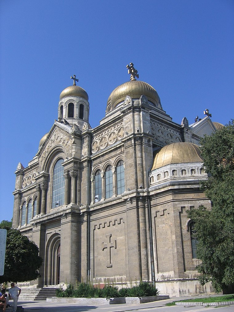 The Dormition of the Mother of God Cathedral is the largest church building in Varna and the third largest cathedral in Bulgaria. Officially opened on 30 August 1886, it is the residence of the bishopric of Varna and Preslav and one of the symbols of Varna. Dormition of the Mother of God Cathedral, Varna is situated 1 km south of School gym building.
Places in the Area
Nearby places include Varna and Centre.
Varna

Photo: Vicki Burton, CC BY-SA 2.0.
Varna is a large city on the Black Sea coast in the northeast of Bulgaria. It's the larger of the country's two major sea ports, and a gateway to the seaside resorts on the northern part of the coast.


School gym building
- Type: School building
- Categories: building and education
- Location: Varna, Bulgaria, Balkans, Europe
- View on OpenStreetMap
Latitude
43.2144° or 43° 12′ 52″ northLongitude
27.91207° or 27° 54′ 44″ eastLevels
2Height
7 metres (23 feet)Open location code
8GM96W76+QROpenStreetMap ID
way 689433841OpenStreetMap feature
building=school
This page is based on OpenStreetMap, Wikidata, and Wikimedia Commons.
We’d love your help improving our open data sources. Thank you for contributing.
Satellite Map
Discover School gym building from above in high-definition satellite imagery.
Notable Places Nearby
Highlights include Secondary School Vasil Aprilov and Факултет по фармация.
Nearby Places
Explore places such as Стария чинар and Гала.
Bulgaria: Must-Visit Destinations
Delve into Sofia, Veliko Tarnovo, Varna, and Plovdiv.
Curious Places to Discover
Uncover intriguing places from every corner of the globe.
About Mapcarta. Data © OpenStreetMap contributors and available under the Open Database License". Text is available under the CC BY-SA 4.0 license, except for photos, directions, and the map. Photo: Pamporoff, Public domain.