Spielplatz An St. Heinrich 2
Spielplatz An St. Heinrich 2 is a playground in Marl, Recklinghausen, North Rhine-Westphalia. Spielplatz An St. Heinrich 2 is situated nearby to the health club Fitness First, as well as near the sports venue Sporthalle Martin-Buber-Schule.| Tap on a place to explore it |
Places of Interest Nearby
Highlights include Sculpture museum of Glaskasten and Town Hall.
Sculpture museum of Glaskasten
Museum
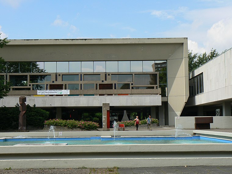
Photo: Gerardus, Public domain.
Sculpture museum of Glaskasten is situated 720 metres west of Spielplatz An St. Heinrich 2.
Town Hall
Town hall

Photo: Threedots, CC BY-SA 3.0.
Town Hall is situated 660 metres west of Spielplatz An St. Heinrich 2.
Marl Mitte station
Railway stop

Photo: Stefan Flöper, CC BY-SA 4.0.
Marl Mitte is a railway station on the Gelsenkirchen-Buer Nord–Marl Lippe railway in Marl in the German state of North Rhine-Westphalia. It is classified by Deutsche Bahn as a category 6 station and was opened on 24 October 1974. Marl Mitte station is situated 410 metres southwest of Spielplatz An St. Heinrich 2.
Places in the Area
Nearby places include Bertlich and Westerholt.
Bertlich
Suburb

Photo: W.Strickling, CC BY-SA 4.0.
Bertlich is a suburb, which is situated 5 km south of Spielplatz An St. Heinrich 2.
Westerholt
Village

Photo: Walter Koch, CC BY-SA 4.0.
Westerholt is a village, which is situated 6 km south of Spielplatz An St. Heinrich 2.
Lippramsdorf
Village
Photo: Stahlkocher, CC BY-SA 3.0.
Lippramsdorf is a village, which is situated 7 km north of Spielplatz An St. Heinrich 2.
Spielplatz An St. Heinrich 2
- Type: Playground
- Category: recreation area
- Location: Marl, Recklinghausen, Münster, North Rhine-Westphalia, Germany, Central Europe, Europe
- View on OpenStreetMap
Latitude
51.65524° or 51° 39′ 19″ northLongitude
7.10503° or 7° 6′ 18″ eastOperator
Stadt MarlOpen location code
9F39M444+32OpenStreetMap ID
way 706994863OpenStreetMap feature
leisure=playground
This page is based on OpenStreetMap, Wikidata, and Wikimedia Commons.
We’d love your help improving our open data sources. Thank you for contributing.
Satellite Map
Discover Spielplatz An St. Heinrich 2 from above in high-definition satellite imagery.
Notable Places Nearby
Highlights include Spielplatz an St. Heinrich and St.Heinrich.
Nearby Places
Explore places such as Pro Talis Seniorenzentrum and Ev. Kita Paul-Schneider-Straße.
North Rhine-Westphalia: Must-Visit Destinations
Delve into Cologne, Düsseldorf, Bonn, and Dortmund.
Curious Playgrounds to Discover
Uncover intriguing playgrounds from every corner of the globe.
About Mapcarta. Data © OpenStreetMap contributors and available under the Open Database License". Text is available under the CC BY-SA 4.0 license, except for photos, directions, and the map. Photo: Daniel Schwen, CC BY-SA 2.5.