St Kieran’s Cemetery, Coosan
St Kieran’s Cemetery, Coosan is a cemetery in County Westmeath, Leinster. St Kieran’s Cemetery, Coosan is situated nearby to the village Baylin.| Tap on a place to explore it |
Places of Interest Nearby
Highlights include Athlone and Athlone Castle.
Athlone
Railway station

Photo: Wikimedia, CC BY-SA 2.0.
Athlone railway station is a station which serves the town of Athlone in County Roscommon and County Westmeath. It is located in the town on the east side of the river Shannon. Athlone is situated 2½ km south of St Kieran’s Cemetery, Coosan.
Athlone Castle
Museum
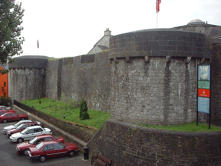
Photo: Sgbrito, Public domain.
Athlone Castle, sometimes known as Adamson Castle, is a castle located in Athlone, County Westmeath, Ireland, dating from the 12th century. Athlone Castle is situated 3 km south of St Kieran’s Cemetery, Coosan.
Golden Island Shopping Centre
Shopping center

Photo: Wikimedia, CC BY-SA 3.0.
Golden Island Shopping Centre is a shopping centre located in Athlone, County Westmeath, Ireland. Golden Island Shopping Centre is situated 3 km south of St Kieran’s Cemetery, Coosan.
Places in the Area
Nearby places include Athlone and Baylin.
Athlone

Photo: Imehling, CC BY-SA 3.0.
Athlone is a town in County Westmeath, almost dead-centre of Ireland and bisected by the River Shannon. The promenade on the River Shannon is popular among anglers, birdwatchers and swimmers.
Baylin
Village
Baylin, also written Bealin is a village in County Westmeath, Ireland, about 5 kilometres east of Athlone. Its postal address is Baylin, Athlone, County Westmeath, Ireland. Baylin is situated 6 km east of St Kieran’s Cemetery, Coosan.
Tubberclare
Village

Photo: Sarah777, Public domain.
Tubberclare or Tubberclair is a village and townland in County Westmeath, Ireland, between Ballymahon and Athlone. It lies 9 km from Athlone, on the N55 national secondary road, and 2 km north of Glasson. Tubberclare is situated 7 km northeast of St Kieran’s Cemetery, Coosan.
St Kieran’s Cemetery, Coosan
- Type: Cemetery
- Denomination: Roman Catholic
- Category: burial
- Location: County Westmeath, Leinster, East Coast and Midlands, Ireland, Britain and Ireland, Europe
- View on OpenStreetMap
Latitude
53.44875° or 53° 26′ 56″ northLongitude
-7.93571° or 7° 56′ 9″ westOpen location code
9C5JC3X7+FPOpenStreetMap ID
way 721307566OpenStreetMap feature
landuse=cemeteryOpenStreetMap attribute
denomination=roman_catholic
This page is based on OpenStreetMap, Wikidata, and Wikimedia Commons.
We’d love your help improving our open data sources. Thank you for contributing.
Satellite Map
Discover St Kieran’s Cemetery, Coosan from above in high-definition satellite imagery.
Notable Places Nearby
Highlights include Pilates Olive Keyes and Queen of Peace Church.
Nearby Places
Explore places such as Coosan National School and Veterinary Clinic.
Curious Cemeteries to Discover
Uncover intriguing cemeteries from every corner of the globe.
About Mapcarta. Data © OpenStreetMap contributors and available under the Open Database License". Text is available under the CC BY-SA 4.0 license, except for photos, directions, and the map. Photo: Wikimedia, CC0.