La Hoya de Anamosa
La Hoya de Anamosa is a meadow in La Frontera, Santa Cruz de Tenerife. La Hoya de Anamosa is situated nearby to the volcano Tajusara, as well as near the spring Fuente de Mencáfete.| Tap on a place to explore it |
Places of Interest Nearby
Highlights include Tanganasoga and Ermita de Nuestra señora de los Reyes.
Tanganasoga
Volcano
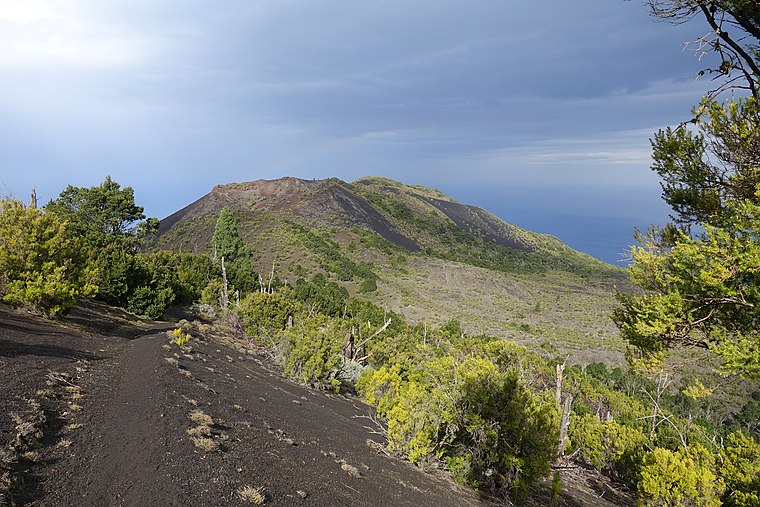
Photo: Areuland, CC BY-SA 4.0.
Tanganasoga is the main volcano of El Hierro's El Golfo area in the Canary Islands, consisting of a cinder cone. The volcano is part of a much larger shield volcano system. Tanganasoga is situated 3 km east of La Hoya de Anamosa.
Ermita de Nuestra señora de los Reyes
Church

Photo: barraquito, CC BY-SA 2.0.
Ermita de Nuestra señora de los Reyes is a church, which is situated 3 km west of La Hoya de Anamosa.
Places in the Area
Nearby places include Sabinosa and Pozo de la Salud.

Pozo de la Salud
Hamlet

Photo: Wikimedia, CC BY-SA 2.0.
Pozo de la Salud is a hamlet, which is situated 3 km northwest of La Hoya de Anamosa.
La Hoya de Anamosa
- Type: Meadow
- Also known as: “Hoya La Moza”
- Location: La Frontera, Santa Cruz de Tenerife, Canary Islands, Spain, Iberia, Europe
- View on OpenStreetMap
Latitude
27.73284° or 27° 43′ 58″ northLongitude
-18.08923° or 18° 5′ 21″ westOpen location code
7CV3PWM6+48OpenStreetMap ID
way 738288666OpenStreetMap feature
landuse=meadow
This page is based on OpenStreetMap, Wikidata, and Wikimedia Commons.
We’d love your help improving our open data sources. Thank you for contributing.
Satellite Map
Discover La Hoya de Anamosa from above in high-definition satellite imagery.
Notable Places Nearby
Highlights include Tajusara and Depósito de Tajusara.
Nearby Places
Explore places such as Cruz de los Humilladeros and Centro Medico.
Canary Islands: Must-Visit Destinations
Delve into Santa Cruz de Tenerife, Las Palmas, La Palma, and La Gomera.
Curious Meadows to Discover
Uncover intriguing meadows from every corner of the globe.
About Mapcarta. Data © OpenStreetMap contributors and available under the Open Database License". Text is available under the CC BY-SA 4.0 license, except for photos, directions, and the map. Photo: Wikimedia, CC BY-SA 4.0.