Seguridad Social
Seguridad Social is a public building in Santa Cruz de Tenerife, Tenerife. Seguridad Social is situated nearby to the recreation area Bingo Hípico, as well as near the public building Edificio Usos Múltiples II.| Tap on a place to explore it |
Places of Interest Nearby
Highlights include Auditorio de Tenerife and Museo de la Naturaleza y Arqueología.
Auditorio de Tenerife
Arts center
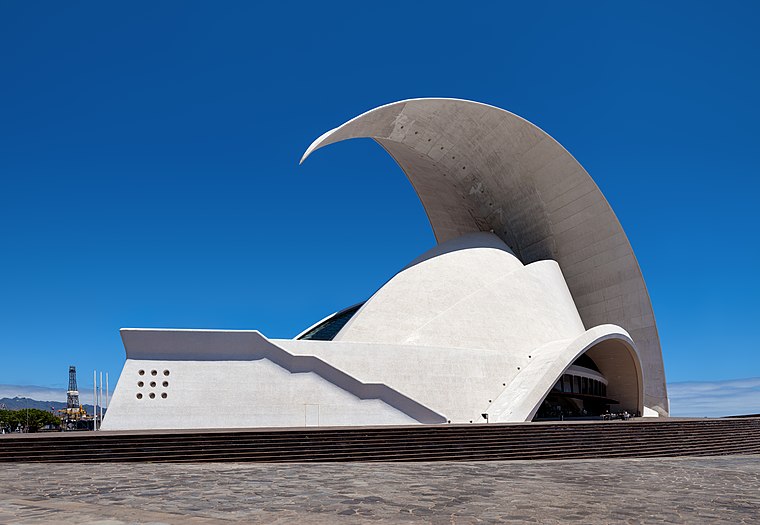
Photo: Der Wolf im Wald, CC BY-SA 3.0 de.
The Auditorio de Tenerife "Adán Martín" is an auditorium in Santa Cruz de Tenerife, Canary Islands, Spain. Designed by architect Santiago Calatrava, it is located on the Avenue of the Constitution in the Canarian capital, and next to the Atlantic Ocean in the southern part of Port of Santa Cruz de Tenerife. Auditorio de Tenerife is situated 590 metres south of Seguridad Social.
Museo de la Naturaleza y Arqueología
Museum

Photo: VolcánTeide, CC BY-SA 3.0.
Museo de la Naturaleza y Arqueología, is a museum-based in Santa Cruz de Tenerife, Tenerife. It contains many significant archaeological finds and is considered the best repository of objects from the Pre-Castilian Canary Islands. Museo de la Naturaleza y Arqueología is situated 310 metres northeast of Seguridad Social.
Presidential Palace in Santa Cruz de Tenerife
Public building
 Presidential Palace in Santa Cruz de Tenerife is a public building.
Places in the Area
Nearby places include Cuatro Torres and San Sebastián.


Seguridad Social
- Type: Public building
- Categories: building and government building
- Location: Santa Cruz de Tenerife, Santa Cruz de Tenerife, Tenerife, Canary Islands, Spain, Iberia, Europe
- View on OpenStreetMap
Latitude
28.46142° or 28° 27′ 41″ northLongitude
-16.25097° or 16° 15′ 4″ westOpen location code
7CW5FP6X+HJOpenStreetMap ID
way 77621864OpenStreetMap feature
building=public
This page is based on OpenStreetMap, Wikidata, and Wikimedia Commons.
We’d love your help improving our open data sources. Thank you for contributing.
Satellite Map
Discover Seguridad Social from above in high-definition satellite imagery.
Places with the Same Name
Discover other places named “Seguridad Social”.
Notable Places Nearby
Highlights include Direccion Provincial del Instituto Nacional de la Seguridad Social and Direccion Provincial de la Tesoreria General de la Seguridad Social.
Nearby Places
Explore places such as Residencia Militar and Edificio el Cabo.
Tenerife: Must-Visit Destinations
Delve into San Cristóbal de La Laguna, Teide National Park, Puerto de la Cruz, and Candelaria.
Curious Public Buildings to Discover
Uncover intriguing public buildings from every corner of the globe.
About Mapcarta. Data © OpenStreetMap contributors and available under the Open Database License". Text is available under the CC BY-SA 4.0 license, except for photos, directions, and the map. Photo: Wikimedia, CC BY-SA 3.0.