Centrale photovoltaïque de Labarde
Centrale photovoltaïque de Labarde is a power station in Gironde, Nouvelle-Aquitaine. Centrale photovoltaïque de Labarde is situated nearby to the river Estey de la Jallère, as well as near the college Compagnons du Devoir.| Tap on a place to explore it |
Places of Interest Nearby
Highlights include Stade Atlantique and Vélodrome de Bordeaux.
Stade Atlantique
Stadium
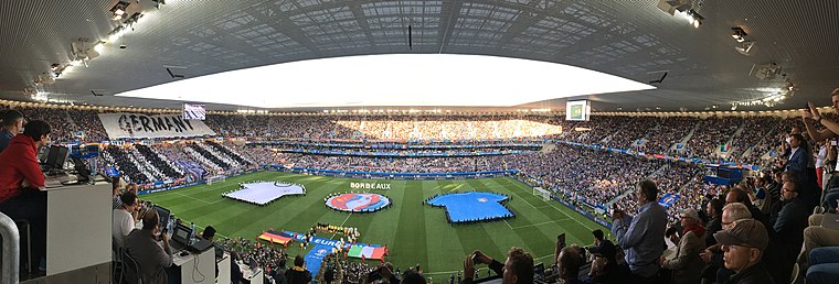 The Stade Atlantique, also known as the Nouveau Stade de Bordeaux, is a football stadium in Bordeaux, France. It is the home of Championnat National 2 club FC Girondins de Bordeaux and seats 42,115 spectators. The sponsor Matmut is a French insurance company. Stade Atlantique is situated 1¼ km southwest of Centrale photovoltaïque de Labarde.
Vélodrome de Bordeaux
Stadium
The Vélodrome de Bordeaux is a velodrome in Bordeaux, France. It hosted the UCI Track Cycling World Championships in 1998 and 2006. Building started in 1987 and the velodrome was opened on 9 October 1989. Vélodrome de Bordeaux is situated 1½ km west of Centrale photovoltaïque de Labarde.
Berges de la Garonne tram stop
Tram stop

Photo: Smiley.toerist, CC BY-SA 4.0.
Berges de la Garonne tram stop is located on line B of the Tramway de Bordeaux. It opened on 20 June 2014, when the line was extended from Claveau, and is the current northern terminus of line B. Berges de la Garonne tram stop is situated 2 km south of Centrale photovoltaïque de Labarde.
Places in the Area
Nearby places include Bassens and Lormont.
Bassens
Village

Photo: Wikimedia, Public domain.
Bassens is a commune in the Gironde department in southwestern France. Bassens is situated 2½ km east of Centrale photovoltaïque de Labarde.
Lormont
Town

Photo: Christophe Durand, CC BY-SA 2.0.
Lormont is a commune in the Gironde department, Nouvelle-Aquitaine, southwestern France. It is a suburb of the city of Bordeaux and is adjacent to it on the northeast. Thus, it is a member of the intercommunality Bordeaux Métropole. Lormont is situated 3½ km southeast of Centrale photovoltaïque de Labarde.
Les Aubiers
Suburb

Photo: Vince034, CC BY-SA 4.0.
Les Aubiers is a suburb, which is situated 3½ km southwest of Centrale photovoltaïque de Labarde.
Centrale photovoltaïque de Labarde
- Type: Power station
- Also known as: “centrale solaire de Labarde”
- Category: industry
- Location: Gironde, Nouvelle-Aquitaine, France, Europe
- View on OpenStreetMap
Latitude
44.90245° or 44° 54′ 9″ northLongitude
-0.54884° or 0° 32′ 56″ westInception
February 11th, 2021Open location code
8CPXWF22+XFOpenStreetMap ID
way 788895597
This page is based on OpenStreetMap, Wikidata, and Wikimedia Commons.
We’d love your help improving our open data sources. Thank you for contributing.
Satellite Map
Discover Centrale photovoltaïque de Labarde from above in high-definition satellite imagery.
Notable Places Nearby
Highlights include Estey de la Jallère and Compagnons du Devoir.
Nearby Places
Explore places such as Jallère and Jallère.
Gironde: Must-Visit Destinations
Delve into Bordeaux, Arcachon, Saint-Émilion, and Soulac-sur-Mer.
Curious Power Stations to Discover
Uncover intriguing power stations from every corner of the globe.
About Mapcarta. Data © OpenStreetMap contributors and available under the Open Database License". Text is available under the CC BY-SA 4.0 license, except for photos, directions, and the map. Photo: JLPC, CC BY-SA 3.0.