Nissan Autohaus Giselheid
Nissan Autohaus Giselheid is a car dealership in Goslar, Southern Lower Saxony, Lower Saxony which is located on Bornhardtstraße. Nissan Autohaus Giselheid is situated nearby to Bowling-Center Baßgeige, as well as near the public building Finanzamt.| Tap on a place to explore it |
Places of Interest Nearby
Highlights include Christian-von-Dohm-Gymnasium and Polizeiinspektion Goslar.
Christian-von-Dohm-Gymnasium
School

Photo: Reise Reise, CC BY-SA 3.0.
Christian-von-Dohm-Gymnasium is a school, which is situated 410 metres southeast of Nissan Autohaus Giselheid.
Polizeiinspektion Goslar
Police station

Photo: Reise Reise, CC BY-SA 3.0.
Polizeiinspektion Goslar is a police station, which is situated 770 metres southeast of Nissan Autohaus Giselheid.
Goslar station
Railway station
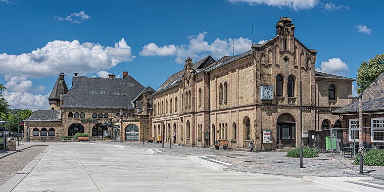 Goslar is a railway station located in Goslar, Germany. The station opened on 23 March 1866 and is located on the Vienenburg–Goslar railway, Hildesheim–Goslar railway and Neuekrug-Hahausen–Goslar railway. Goslar station is situated 1½ km south of Nissan Autohaus Giselheid.
Places in the Area
Nearby places include Baßgeige and Fliegerhorst.


Nissan Autohaus Giselheid
- Type: Car dealership
- Address: Bornhardtstraße 9, Goslar, 38644
- Categories: building, shop, and transportation
- Location: Goslar, Goslar, Southern Lower Saxony, Lower Saxony, Germany, Central Europe, Europe
- View on OpenStreetMap
Latitude
51.92471° or 51° 55′ 29″ northLongitude
10.41948° or 10° 25′ 10″ eastBrand
NissanOperator
Autohaus Giselheid GmbHOpen location code
9F3GWCF9+VQOpenStreetMap ID
way 80552039OpenStreetMap feature
building=yesOpenStreetMap feature
shop=car
This page is based on OpenStreetMap, Wikidata, and Wikimedia Commons.
We’d love your help improving our open data sources. Thank you for contributing.
Satellite Map
Discover Nissan Autohaus Giselheid from above in high-definition satellite imagery.
Notable Places Nearby
Highlights include Bowling-Center Baßgeige and Finanzamt.
Nearby Places
Explore places such as Goslar, Finanzamt Bussteig A and Hempelmann Haustechnik.
Southern Lower Saxony: Must-Visit Destinations
Delve into Göttingen, Hamelin, Hann. Münden, and Einbeck.
Curious Car Dealerships to Discover
Uncover intriguing car dealerships from every corner of the globe.
About Mapcarta. Data © OpenStreetMap contributors and available under the Open Database License". Text is available under the CC BY-SA 4.0 license, except for photos, directions, and the map. Photo: Wikimedia, CC0.