EMV-Halle 76.1
EMV-Halle 76.1 is an industrial building in Munich, Upper Bavaria, Bavaria. EMV-Halle 76.1 is situated nearby to BMW Group Research and Innovation Center, as well as near the metro station Am Hart station.| Tap on a place to explore it |
Places of Interest Nearby
Highlights include Am Hart station and Hinterhoftheater.
Am Hart station
Metro station

Photo: Wikimedia, CC BY-SA 4.0.
Am Hart is an U-Bahn station in Munich on the U2. Am Hart station is situated 320 metres east of EMV-Halle 76.1.
Hinterhoftheater
Theater building
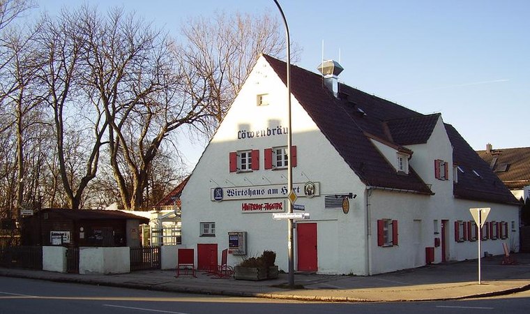
Photo: Gamsbart, CC BY-SA 3.0.
Hinterhoftheater is a theatre in Munich, Bavaria, Germany. Hinterhoftheater is situated 670 metres east of EMV-Halle 76.1.
BMW Group Research and Innovation Center

Photo: Gamsbart, CC BY 3.0 de.
The BMW Group Forschungs- und Innovationszentrum is the main engineering and development campus of the BMW Group. It is located in Milbertshofen-Am Hart, a district in northern Munich. BMW Group Research and Innovation Center is situated 260 metres southeast of EMV-Halle 76.1.
Places in the Area
Nearby places include Virginia-Depot and Am Hart.
Virginia-Depot
Locality
The Virginia depot was a military camp used last by the Bundeswehr west of Schleißheimer Straße in the Munich district of Lerchenau. Today it is a biotope with rare plant species.
Am Hart
Suburb

Photo: FlocciNivis, CC BY 4.0.
Am Hart is the northernmost of the three sub-districts of the Munich city district 11 Milbertshofen-Am Hart.
Harthof
Suburb
Harthof is a district in the north of the Bavarian capital Munich. It is located in districts 11 Milbertshofen-Am Hart and 24 Feldmoching-Hasenbergl. Harthof consists of medium-sized housing estates and an estate of older council flats.
EMV-Halle 76.1
- Type: Industrial building
- Categories: building and industry
- Location: Munich, Upper Bavaria, Bavaria, Germany, Central Europe, Europe
- View on OpenStreetMap
Latitude
48.19552° or 48° 11′ 44″ northLongitude
11.56758° or 11° 34′ 3″ eastLevels
4Open location code
8FWH5HW9+62OpenStreetMap ID
way 8158448OpenStreetMap feature
building=industrial
This page is based on OpenStreetMap, Wikidata, and Wikimedia Commons.
We’d love your help improving our open data sources. Thank you for contributing.
Satellite Map
Discover EMV-Halle 76.1 from above in high-definition satellite imagery.
Notable Places Nearby
Highlights include Polizeiinspektion München 47 (Milbertshofen) and Münchner Volkshochschule Stadtbereichszentrum Nord.
Nearby Places
Explore places such as 76.4 and Entladehof 70, 71, 72.
Munich: Must-Visit Destinations
Delve into North Munich, Altstadt, Haidhausen, and Ludwigsvorstadt-Isarvorstadt.
Curious Industrial Buildings to Discover
Uncover intriguing industrial buildings from every corner of the globe.
About Mapcarta. Data © OpenStreetMap contributors and available under the Open Database License". Text is available under the CC BY-SA 4.0 license, except for photos, directions, and the map. Photo: Heav84, CC BY-SA 3.0.