Massachusetts College of Pharmacy & Health Sciences
Massachusetts College of Pharmacy & Health Sciences is a college in City of Worcester, Massachusetts. Massachusetts College of Pharmacy & Health Sciences is situated nearby to Wesley United Methodist Church, as well as near Salisbury Factory Building.| Tap on a place to explore it |
Places of Interest Nearby
Highlights include Worcester Palladium and Clark University.
Worcester Palladium
Theater building
 The Worcester Palladium, also known as The Palladium or Palladium Theatre, is an all-ages concert hall and performance venue located in Worcester, Massachusetts. Worcester Palladium is situated 1,000 feet south of Massachusetts College of Pharmacy & Health Sciences.
Clark University
University
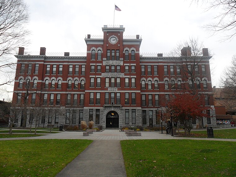
Photo: Namiba, Public domain.
Clark University is a private research university in Worcester, Massachusetts, United States. Founded in 1887 with a large endowment from its namesake Jonas Gilman Clark, a prominent businessman, Clark was one of the first modern research universities in the United States. Clark University is situated 3,600 feet west of Massachusetts College of Pharmacy & Health Sciences.
Worcester Memorial Auditorium
Theater building

Photo: Kzirkel, CC BY-SA 4.0.
Worcester Memorial Auditorium is a multi-purpose arena located at Lincoln Square in Worcester, Massachusetts. It was built in 1933 to honor Worcester citizens who fought in World War I. Worcester Memorial Auditorium is situated 940 feet northwest of Massachusetts College of Pharmacy & Health Sciences.
Places in the Area
Nearby places include Lower Pleasant Street District and Worcester.
Lower Pleasant Street District
Neighborhood
 The Lower Pleasant Street District is an historic district at 418–426 Main Street and 9–49 Pleasant Street in Worcester, Massachusetts. It encompasses the only surviving row of Victorian-era commercial buildings in downtown Worcester.
Worcester

Photo: Godsendlemiwinks, CC BY-SA 4.0.
Explore fine arts, history, and take in a show in Worcester, a medium sized city in Central Massachusetts about an hour's drive west of Boston. Worcester's seven hills and their valleys contain top notch museums, nine colleges and universities, beautiful parks, and food from all over the globe.
Lincoln Estate–Elm Park Historic District
Neighborhood

Photo: Faolin42, CC BY-SA 3.0.
The Lincoln Estate–Elm Park Historic District is an expansive residential area in northwestern Worcester, Massachusetts. It is centered on Cedar and William Streets, and includes properties on adjacent streets.
Massachusetts College of Pharmacy & Health Sciences
- Type: College
- Also known as: “Massachusetts College of Pharmacy & Health Sciences Worcester Campus”
- Category: education
- Location: City of Worcester, Worcester, Massachusetts, New England, United States, North America
- View on OpenStreetMap
Latitude
42.26948° or 42° 16′ 10″ northLongitude
-71.79945° or 71° 47′ 58″ westOpen location code
87JC7692+Q6OpenStreetMap ID
way 819543864OpenStreetMap feature
amenity=college
This page is based on OpenStreetMap, Wikidata, and Wikimedia Commons.
We’d love your help improving our open data sources. Thank you for contributing.
Satellite Map
Discover Massachusetts College of Pharmacy & Health Sciences from above in high-definition satellite imagery.
Places with the Same Name
Discover other places named “Massachusetts College of Pharmacy & Health Sciences”.
Notable Places Nearby
Highlights include Wesley United Methodist Church and Salisbury Factory Building.
Nearby Places
Explore places such as MCPHS Forsyth Dental Hygiene Clinic and MCPHS Eye and Vision Center.
Massachusetts: Must-Visit Destinations
Delve into Boston, Cambridge, Springfield, and Downtown Boston.
Curious Colleges to Discover
Uncover intriguing colleges from every corner of the globe.
About Mapcarta. Data © OpenStreetMap contributors and available under the Open Database License". Text is available under the CC BY-SA 4.0 license, except for photos, directions, and the map. Photo: papadunes, CC BY-SA 3.0.