Norfolk Fire Station 6
Norfolk Fire Station 6 is a fire station in Norfolk, Virginia. Norfolk Fire Station 6 is situated nearby to Central Baptist Church, as well as near Brickell Library.| Tap on a place to explore it |
Places of Interest Nearby
Highlights include EVMC/Fort Norfolk station and USS Wisconsin.
EVMC/Fort Norfolk station
Railway station
 EVMC/Fort Norfolk station is a Tide Light Rail station in Norfolk, Virginia. It opened in 2011 and is the western terminus of the line. It is situated at the intersection of Brambleton and Colley Avenues, just west of downtown and south of the historic Ghent district. EVMC/Fort Norfolk station is situated 680 feet southwest of Norfolk Fire Station 6.
USS Wisconsin
Museum

Photo: Wikimedia, Public domain.
USS Wisconsin is an Iowa-class battleship built for the United States Navy in the 1940s and is currently a museum ship. Completed in 1944, the ship was assigned to the Pacific Theater during World War II, where she participated in the Philippines campaign and the Battles of Iwo Jima and Okinawa. USS Wisconsin is situated 1 mile southeast of Norfolk Fire Station 6.
Chrysler Museum of Art
Museum
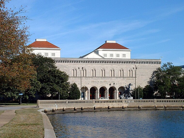
Photo: Gosscj, Public domain.
The Chrysler Museum of Art is an art museum on the border between downtown and the Ghent district of Norfolk, Virginia. The museum was founded in 1933 as the Norfolk Museum of Arts and Sciences. Chrysler Museum of Art is situated 2,800 feet southeast of Norfolk Fire Station 6.
Places in the Area
Nearby places include Park Place Historic District and Huntersville.
Park Place Historic District
Neighborhood

Photo: Nyttend, Public domain.
Park Place is a neighborhood in the western half of Norfolk, Virginia. Its boundaries are roughly Granby Street on the east, Colley Avenue on the west, 23rd Street on the south and up to 38th Street to the north.
Huntersville
Neighborhood

Photo: Packer1028, CC0.
Huntersville is a historic neighborhood in Norfolk, Virginia. It is located near downtown Norfolk. One of Norfolk's "most intact settlements remaining from the late 19th century," Huntersville "is unique because it was not planned by a company or commission, but developed over time."…
Portsmouth Olde Towne Historic District
Quarter

Photo: KLOTZPLATE, CC BY-SA 4.0.
Portsmouth Olde Towne Historic District, is a national historic district located at Portsmouth, Virginia. It encompasses 89 buildings. It is located in the primarily residential section of Portsmouth and includes a notable collection of Federal and Greek…
Norfolk Fire Station 6
- Type: Fire station
- Location: Norfolk, Virginia, South, United States, North America
- View on OpenStreetMap
Latitude
36.85967° or 36° 51′ 35″ northLongitude
-76.30155° or 76° 18′ 6″ westOperator
City of NorfolkOpen location code
8785VM5X+V9OpenStreetMap ID
way 822784724OpenStreetMap feature
amenity=fire_station
This page is based on OpenStreetMap, Wikidata, and Wikimedia Commons.
We’d love your help improving our open data sources. Thank you for contributing.
Satellite Map
Discover Norfolk Fire Station 6 from above in high-definition satellite imagery.
Notable Places Nearby
Highlights include Central Baptist Church and Brickell Library.
Nearby Places
Explore places such as Ronald McDonald House Charities and EVMS Waitzer Hall.
Virginia: Must-Visit Destinations
Delve into Richmond, Arlington, Virginia Beach, and Alexandria.
Curious Fire Stations to Discover
Uncover intriguing fire stations from every corner of the globe.
About Mapcarta. Data © OpenStreetMap contributors and available under the Open Database License". Text is available under the CC BY-SA 4.0 license, except for photos, directions, and the map. Photo: UED77, CC BY-SA 3.0.