Trans Canada Trail Pavillion
Trans Canada Trail Pavillion is a shelter in Vancouver, British Columbia. Trans Canada Trail Pavillion is situated nearby to the public building False Creek Community Centre, as well as near Granville Island Water Park.| Tap on a place to explore it |
Places of Interest Nearby
Highlights include Granville Street Bridge and BC Place.
Granville Street Bridge
Bridge
The Granville Street Bridge or Granville Bridge is an eight-lane fixed cantilever/truss bridge in Vancouver, British Columbia, Canada, carrying Granville Street between Downtown Vancouver southwest and the Fairview neighborhood. Granville Street Bridge is situated 220 metres north of Trans Canada Trail Pavillion.
BC Place
Stadium

Photo: Yvrphoto, CC BY-SA 3.0.
BC Place is a multi-purpose stadium in Vancouver, British Columbia, Canada. Located at the north side of False Creek, it is owned and operated by the BC Pavilion Corporation, a Crown corporation of the province. BC Place is situated 2 km northeast of Trans Canada Trail Pavillion.
Granville Island Hotel
Hotel
Granville Island Hotel is a hotel in Vancouver, British Columbia, Canada. The hotel is located on Granville Island and is cited as "one of Vancouver's best kept secrets". Granville Island Hotel is situated 240 metres east of Trans Canada Trail Pavillion.
Places in the Area
Nearby places include Granville Island and Yaletown.
Granville Island
Neighborhood
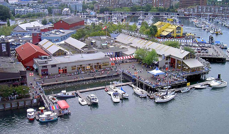
Photo: Zhatt, Public domain.
Granville Island is a peninsula and shopping district in the Fairview neighbourhood of Vancouver, British Columbia, Canada, across False Creek from Downtown Vancouver, under the south end of the Granville Street Bridge.
Yaletown
Neighborhood
Yaletown is an area of Downtown Vancouver, Canada, bordered by False Creek and Robson and Homer Streets. Formerly a heavy industrial area dominated by warehouses and rail yards, since the 1986 World's Fair it has been transformed into one of the most densely populated neighbourhoods in the city.
Yaletown-False Creek

Photo: Thom Quine, CC BY 2.0.
Yaletown-False Creek encompasses the established neighbourhood of Yaletown and the still-developing area of Southeast False Creek. Reclaimed industrial areas, both neighbourhoods are a mix of modern condo architecture and restored industrial warehouses.
Trans Canada Trail Pavillion
- Type: Shelter
- Categories: building and canopy
- Location: Vancouver, Metro Vancouver Regional District, British Columbia, Canada, North America
- View on OpenStreetMap
Latitude
49.26875° or 49° 16′ 8″ northLongitude
-123.13423° or 123° 8′ 3″ westOpen location code
84XR7V98+F8OpenStreetMap ID
way 827789217OpenStreetMap feature
amenity=shelterOpenStreetMap feature
building=roof
This page is based on OpenStreetMap, Wikidata, and Wikimedia Commons.
We’d love your help improving our open data sources. Thank you for contributing.
Satellite Map
Discover Trans Canada Trail Pavillion from above in high-definition satellite imagery.
Places with the Same Name
Discover other places named “Trans Canada Trail Pavillion”.
Notable Places Nearby
Highlights include False Creek Community Centre and Granville Island Water Park.
Nearby Places
Explore places such as Dean’s Food Store and Picnic Pavillion.
British Columbia: Must-Visit Destinations
Delve into Vancouver, Victoria, North Vancouver, and City Centre.
Curious Shelters to Discover
Uncover intriguing shelters from every corner of the globe.
About Mapcarta. Data © OpenStreetMap contributors and available under the Open Database License". Text is available under the CC BY-SA 4.0 license, except for photos, directions, and the map. Photo: Thom Quine, CC BY 2.0.