nagrobek Klawitterów
nagrobek Klawitterów is a cemetery in Gdańsk, Pomorskie. nagrobek Klawitterów is situated nearby to Parafia Bożego Ciała, as well as near Cemetery of Lost Cemeteries.| Tap on a place to explore it |
Places of Interest Nearby
Highlights include Gdańsk Główny Railway Station and Cemetery of Lost Cemeteries.
Gdańsk Główny Railway Station
Railway station
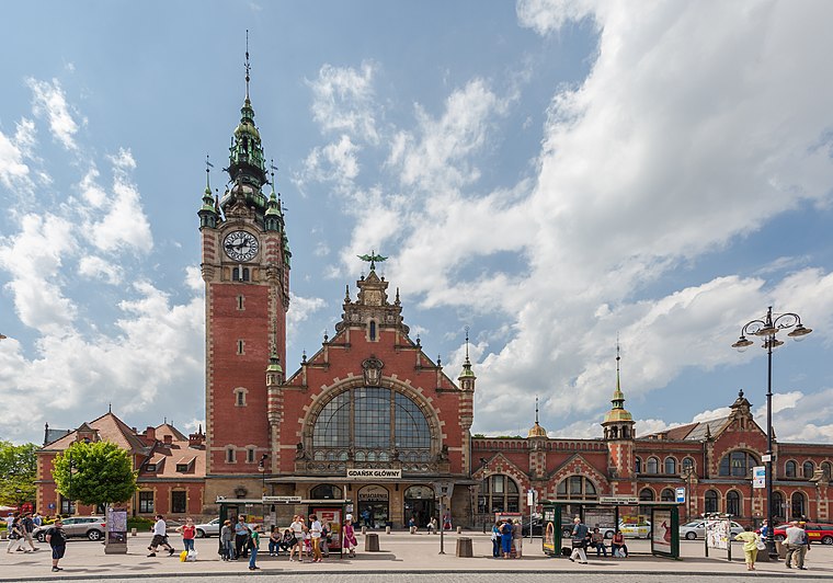
Photo: Wikimedia, CC BY-SA 3.0.
Gdańsk Główny is the chief railway station serving the city of Gdańsk, in the Pomeranian Voivodeship, Poland. The station opened in 1900 and is located on the Warsaw–Gdańsk railway, Gdańsk–Stargard railway, the parallel Gdańsk Śródmieście–Rumia railway, Gdańsk Główny–Gdańsk Zaspa Towarowa railway and Gdańsk Główny–Gdańsk Nowy Port railway. Gdańsk Główny Railway Station is situated 220 metres southeast of nagrobek Klawitterów.
Cemetery of Lost Cemeteries
Cemetery

Photo: Starscream, CC BY-SA 3.0.
The Cemetery of Lost Cemeteries is a monument constructed in the form of a cemetery, commemorating the destroyed cemeteries of the city of Gdańsk in Poland.

Places in the Area
Nearby places include Grodzisko and Old Town.
Grodzisko
Neighborhood

Photo: Maciej Błędkowski, CC BY-SA 4.0.
Grodzisko, historically known as Góra Gradowa, is a quarter of Śródmieście, a district of Gdańsk.
Old Town
Quarter

Photo: Silar, CC BY-SA 4.0.
The Old Town is a quarter of Śródmieście, a district of Gdańsk. It is the oldest area of the city to be granted city rights or privileges.
Nowe Ogrody
Quarter

Photo: Artur Andrzej, Public domain.
Nowe Ogrody is a quarter and eponymous road in Śródmieście, a district of Gdańsk.
nagrobek Klawitterów
- Type: Cemetery
- Category: burial
- Location: Gdańsk, Pomorskie, Poland, Central Europe, Europe
- View on OpenStreetMap
Latitude
54.35793° or 54° 21′ 29″ northLongitude
18.64207° or 18° 38′ 31″ eastOpen location code
9F6W9J5R+5ROpenStreetMap ID
way 838571884OpenStreetMap feature
amenity=grave_yard
This page is based on OpenStreetMap, Wikidata, and Wikimedia Commons.
We’d love your help improving our open data sources. Thank you for contributing.
Satellite Map
Discover nagrobek Klawitterów from above in high-definition satellite imagery.
Notable Places Nearby
Highlights include Parafia Bożego Ciała and Bastion Jerozolimski.
Nearby Places
Explore places such as P2 Hevelianum and Lew Gdański.
Pomorskie: Must-Visit Destinations
Delve into Gdynia, Sopot, Malbork, and Puck.
Curious Cemeteries to Discover
Uncover intriguing cemeteries from every corner of the globe.
About Mapcarta. Data © OpenStreetMap contributors and available under the Open Database License". Text is available under the CC BY-SA 4.0 license, except for photos, directions, and the map. Photo: Yarl, CC BY-SA 3.0.