Delaware State Police heliport
Delaware State Police heliport is an aerodrome in Kent County, Delaware. Delaware State Police heliport is situated nearby to the hamlet Burwood, as well as near Turnkey.| Tap on a place to explore it |
- Type: Aerodrome
- Description: heliport in Delaware, United States
- Also known as: “DE02” and “Delaware State Police Heliport”
Places of Interest
Highlights include Zion African Methodist Episcopal Church and Jenkins Airport.
Zion African Methodist Episcopal Church
Church

Photo: Cecouchman, CC BY-SA 3.0.
Zion African Methodist Episcopal Church is a historic African Methodist Episcopal church and cemetery located at Camden, Kent County, Delaware. It was originally built in 1845 and re-built after a fire in 1889.
Jenkins Airport
Aerodrome
Jenkins Airport is a public use airport located one nautical mile west of the central business district of Wyoming, a town in Kent County, Delaware, United States. It is privately owned by Joe C. Jenkins.
Polytech High School
School
Polytech High School is located in Woodside, Delaware. It was a vocational school starting in the 1960s and changed to a full-time high school in 1991.
Places in the Area
Nearby places include Camden and Woodside East.
Camden
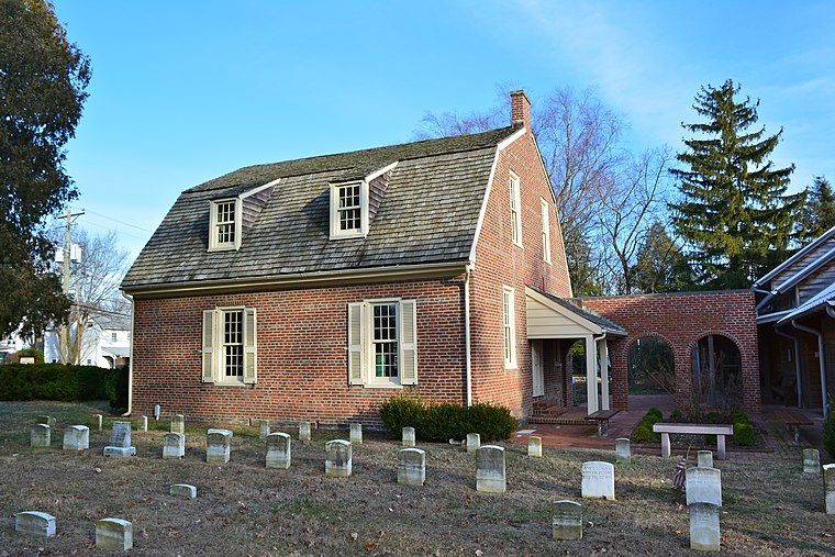
Photo: Smallbones, CC0.
Camden is a town in Kent County, Delaware, United States. It is part of the Dover metropolitan area. The population was 3,715 in 2020.
Woodside East
Village
Woodside East is a census-designated place in Kent County, Delaware, United States. It is part of the Dover, Delaware Metropolitan Statistical Area. The population was 2,316 at the 2010 census.
Rising Sun-Lebanon
Village
Rising Sun-Lebanon is a census-designated place in Kent County, Delaware, United States. It is part of the Dover, Delaware Metropolitan Statistical Area. The population was 3,391 at the 2010 census.
Delaware State Police heliport
- Categories: heliport and transportation
- Location: Kent County, Delaware, Mid-Atlantic, United States, North America
- View on OpenStreetMap
Latitude
39.0898° or 39° 5′ 23″ northLongitude
-75.5577° or 75° 33′ 28″ westOperator
Delaware State PoliceOpen location code
87F63CQR+WWOpenStreetMap ID
way 839785214OpenStreetMap feature
aeroway=aerodromeWikidata ID
Q61671727
This page is based on OpenStreetMap, Wikidata, and Wikimedia Commons.
We’d love your help improving our open data sources. Thank you for contributing.
Satellite Map
Discover Delaware State Police heliport from above in high-definition satellite imagery.
In Other Languages
“Delaware State Police heliport” goes by many names.
- French: “DE02”
- French: “héliport de Delaware State Police”
- French: “Héliport de Delaware State Police”
Localities in the Area
Explore places such as Burwood and Burwood Farms.
Notable Places Nearby
Highlights include Delaware State Police Troop 3 and Chick-fil-A Playplace.
Delaware: Must-Visit Destinations
Delve into Dover, Wilmington, Newark, and New Castle.
Curious Aerodromes to Discover
Uncover intriguing aerodromes from every corner of the globe.
About Mapcarta. Data © OpenStreetMap contributors and available under the Open Database License". Text is available under the CC BY-SA 4.0 license, except for photos, directions, and the map. Photo: Wikimedia, CC0.