Murdock Woods
Murdock Woods is a forest in Tippecanoe, Indiana. Murdock Woods is situated nearby to the neighborhood Oakland Triangle, as well as near Valley Center.| Tap on a place to explore it |
Places of Interest
Highlights include Cathedral of Saint Mary of the Immaculate Conception and Lafayette station.
Cathedral of Saint Mary of the Immaculate Conception
Church

Photo: Nyttend, Public domain.
The Cathedral of Saint Mary of the Immaculate Conception is the cathedral of the Roman Catholic Diocese of Lafayette in Indiana. It is located at 1207 Columbia Street in Lafayette, Indiana. It is also a contributing property in the St. Mary Historic District.
Lafayette station
Railway station
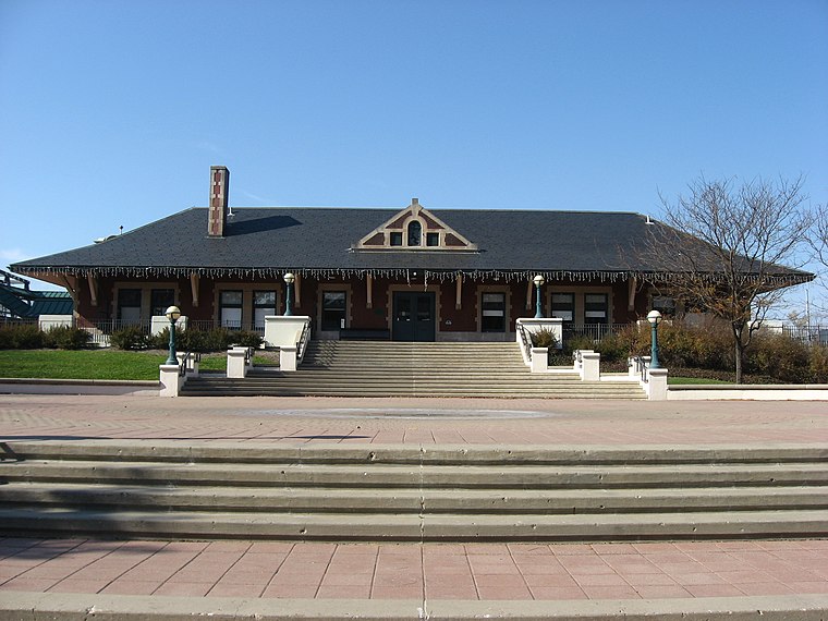
Photo: Nyttend, Public domain.
Lafayette station is an Amtrak station in Lafayette, Indiana, served by the Cardinal. The current station facility was established in 1994. The Amtrak train previously stopped in the middle of the city's 5th Street, near the former Monon Railroad depot.
Franciscan Health Lafayette Central
Hospital
Franciscan Health Lafayette Central, previously known as St. Elizabeth Central, was a 155-bed hospital in Lafayette, Indiana, United States, and part of the Franciscan Health hospital system.
Places in the Area
Nearby places include Lafayette and West Lafayette.
Lafayette

Photo: Wikimedia, CC BY-SA 3.0.
Lafayette is the county seat of Tippecanoe County, Central Indiana. It is located 2 hours southeast of Chicago and 1 hour northwest of Indianapolis. The Greater Lafayette metropolitan area consists of the cities of Lafayette and West Lafayette.
West Lafayette
Town
Photo: Qsthomson, CC BY-SA 3.0.
West Lafayette is a city in Tippecanoe County, Indiana, United States. The population was 44,595 at the 2020 census. West Lafayette sits across the Wabash River from its sister city, Lafayette, and is a college town, home to Purdue University.
Barbarry Heights
Neighborhood
West Lafayette is a city in Tippecanoe County, Indiana, United States. The population was 44,595 at the 2020 census. West Lafayette sits across the Wabash River from its sister city, Lafayette, and is a college town, home to Purdue University.
Murdock Woods
- Type: Forest
- Location: Tippecanoe, Indiana, Midwest, United States, North America
- View on OpenStreetMap
Latitude
40.4227° or 40° 25′ 22″ northLongitude
-86.8748° or 86° 52′ 29″ westOpen location code
86GMC4FG+33OpenStreetMap ID
way 868195325OpenStreetMap feature
natural=wood
This page is based on OpenStreetMap, Wikidata, and Wikimedia Commons.
We’d love your help improving our open data sources. Thank you for contributing.
Satellite Map
Discover Murdock Woods from above in high-definition satellite imagery.
Places with the Same Name
Discover other places named “Murdock Woods”.
Localities in the Area
Explore places such as Oakland Triangle and Valley Center.
Notable Places Nearby
Highlights include Murdock Park and Grace United Methodist Church.
Indiana: Must-Visit Destinations
Delve into Indianapolis, Fort Wayne, Gary, and Evansville.
Curious Forests to Discover
Uncover intriguing forests from every corner of the globe.
About Mapcarta. Data © OpenStreetMap contributors and available under the Open Database License". Text is available under the CC BY-SA 4.0 license, except for photos, directions, and the map. Photo: Wikimedia, CC0.