Centro Radiológico Guadalupe
Centro Radiológico Guadalupe is a clinic in Capital Department, San Juan which is located on Matías Zavalla. Centro Radiológico Guadalupe is situated nearby to the health club Boxeo Mario Cabello, as well as near the college Escuela Nacional de Experimentación y Realización Cinematográfica.| Tap on a place to explore it |
- Email: traumaexpress@hotmail.com
- Type: Clinic
- Address: 447 (N) Matías Zavalla, San Juan, 5400
Places of Interest Nearby
Highlights include Estadio Aldo Cantoni and Auditorio Juan Victoria.
Estadio Aldo Cantoni
Stadium
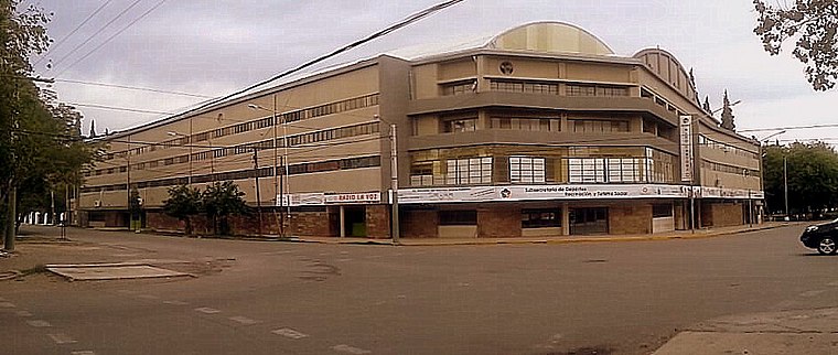 The Estadio Aldo Cantoni is an arena located in the city of San Juan, capital of San Juan Province. Inaugurated in July 1967, it is mainly use by local clubs UPCN and Obras Pocito for their home matches for the Serie A1, the top level of the Argentine men's volleyball league system. Estadio Aldo Cantoni is situated 570 metres southeast of Centro Radiológico Guadalupe.
Auditorio Juan Victoria
Theater building

Photo: Nicoaguiar, CC BY-SA 3.0.
Auditorio Juan Victoria is a theater building, which is situated 530 metres east of Centro Radiológico Guadalupe.
Estadio El Serpentario
Stadium

Photo: Gonce, CC BY-SA 3.0.
Estadio José Nehin, popularly known as El Serpentario, is a football football located in the city of San Juan in the homonymous province of Argentina. It is owned and operated by Club Sportivo Desamparados, and has a capacity of 18,000 spectators. Estadio El Serpentario is situated 1¼ km west of Centro Radiológico Guadalupe.
Places in the Area
Nearby places include San Juan and Villa Paula Albarracín de Sarmiento.
San Juan

Photo: Enrique Guardia, CC0.
San Juan is the capital city of San Juan province, in the central-west Cuyo region of Argentina, about 150 km north of Mendoza. The province has a large Triassic period fossil record, believed to be one of the largest in the world.
Villa Paula Albarracín de Sarmiento
Village
Villa Paula Albarracín de Sarmiento is a locality and the head town of the Chimbas Department, in the San Juan Province of Argentina. It is located in the northern sector of the urban agglomeration of Greater San Juan. Villa Paula Albarracín de Sarmiento is situated 4 km north of Centro Radiológico Guadalupe.
Villa Krause
Town

Photo: Gonce, CC BY-SA 3.0.
Villa Krause is a city in the province of San Juan, Argentina in the Cuyo region. The city is located in the Rawson, east of the San Juan River, at 650 m above mean sea level and has a population of around 107,000 according to the 2001 census. Villa Krause is situated 6 km south of Centro Radiológico Guadalupe.
Centro Radiológico Guadalupe
- Categories: house, health care, and building
- Location: Capital Department, San Juan, Cuyo, Argentina, South America
- View on OpenStreetMap
Latitude
-31.52824° or 31° 31′ 42″ southLongitude
-68.54864° or 68° 32′ 55″ westLevels
1Operator
Facundo BravoOpen location code
47WHFFC2+PGOpenStreetMap ID
way 872022050OpenStreetMap feature
amenity=clinicOpenStreetMap feature
building=houseOpenStreetMap feature
healthcare=clinic
This page is based on OpenStreetMap, Wikidata, and Wikimedia Commons.
We’d love your help improving our open data sources. Thank you for contributing.
Satellite Map
Discover Centro Radiológico Guadalupe from above in high-definition satellite imagery.
Notable Places Nearby
Highlights include Boxeo Mario Cabello and Escuela Nacional de Experimentación y Realización Cinematográfica.
Nearby Places
Explore places such as Raffaelle Nori and Grido Helado.
San Juan: Must-Visit Destinations
Delve into San Juan, Ischigualasto Provincial Park, El Leoncito National Park, and San José de Jáchal.
Curious Clinics to Discover
Uncover intriguing clinics from every corner of the globe.
About Mapcarta. Data © OpenStreetMap contributors and available under the Open Database License". Text is available under the CC BY-SA 4.0 license, except for photos, directions, and the map. Photo: Wikimedia, CC0.