Oklahoma State Department of Health
Oklahoma State Department of Health is a public building in Oklahoma, Great Plains which is located on Northeast 10th Street. Oklahoma State Department of Health is situated nearby to the public building Office of the Chief Medical Examiner, as well as near OU College of Nursing.| Tap on a place to explore it |
Places of Interest Nearby
Highlights include OU Health and Jewel Theater.
OU Health
Hospital
OU Health is Oklahoma’s only comprehensive academic health system, formed in 2020 through the unification of OU Medicine and the University of Oklahoma Health Sciences Center. OU Health is situated 2,500 feet northwest of Oklahoma State Department of Health.
Jewel Theater
Movie theater

Photo: Joel Bradshaw, CC0.
Jewel Theater is a movie theater, which is situated 2,400 feet south of Oklahoma State Department of Health.
Oklahoma State Capitol
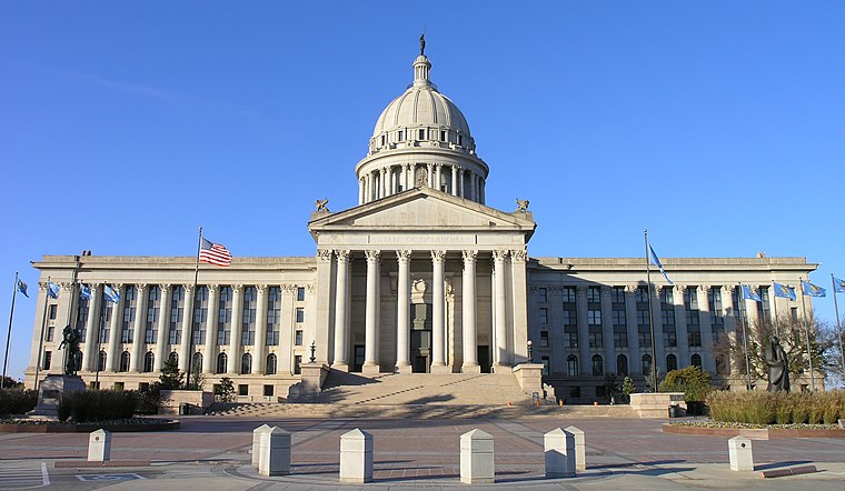
Photo: Maveric149, CC BY-SA 3.0.
The Oklahoma State Capitol is the house of government of the U.S. state of Oklahoma. It is the building that houses the Oklahoma Legislature and executive branch offices. Oklahoma State Capitol is situated 1¼ miles northwest of Oklahoma State Department of Health.
Places in the Area
Nearby places include Bricktown and Downtown Oklahoma City.
Bricktown
Neighborhood

Photo: texasbackroads, CC BY 2.0.
Downtown in Oklahoma City, Oklahoma is the central business district and has several areas, including the Plaza district, Midtown, Automobile Alley, Metro Park, Film Row, Riverside and Bricktown.
Downtown Oklahoma City

Photo: Urbanative, CC BY-SA 3.0.
Downtown in Oklahoma City, Oklahoma is the central business district and has several areas, including the Plaza district, Midtown, Automobile Alley, Metro Park, Film Row, Riverside and Bricktown.
Oklahoma City
 Oklahoma City is the capital and principal city of the state of Oklahoma in the central Frontier Country region of the state. The sprawling city and its suburbs offer multiple sports venues, museums, regional food, and a mix of Native American and cowboy culture.
Oklahoma State Department of Health
- Type: Public building
- Address: 1000 Northeast 10th Street
- Categories: building and government building
- Location: Oklahoma, Great Plains, United States, North America
- View on OpenStreetMap
Latitude
35.47745° or 35° 28′ 39″ northLongitude
-97.49424° or 97° 29′ 39″ westOpen location code
8674FGG4+X8OpenStreetMap ID
way 90091821OpenStreetMap feature
amenity=public_buildingOpenStreetMap feature
building=yes
This page is based on OpenStreetMap, Wikidata, and Wikimedia Commons.
We’d love your help improving our open data sources. Thank you for contributing.
Satellite Map
Discover Oklahoma State Department of Health from above in high-definition satellite imagery.
Notable Places Nearby
Highlights include Office of the Chief Medical Examiner and OU College of Nursing.
Nearby Places
Explore places such as Davita Dialysis Renal Healthcare and Stillwater National Bank.
Oklahoma: Must-Visit Destinations
Delve into Oklahoma City, Tulsa, Norman, and Lawton.
Curious Public Buildings to Discover
Uncover intriguing public buildings from every corner of the globe.
About Mapcarta. Data © OpenStreetMap contributors and available under the Open Database License". Text is available under the CC BY-SA 4.0 license, except for photos, directions, and the map. Photo: Wikimedia, CC0.