HavneBryggen Sirius
HavneBryggen Sirius is a building in Copenhagen municipality, Capital Region. HavneBryggen Sirius is situated nearby to the square Sirius Plads, as well as near Viggo Kampmanns Plads.| Tap on a place to explore it |
Places of Interest Nearby
Highlights include Fisketorvet and Tivoli Gardens.
Fisketorvet
Shopping center

Photo: Kallerna, CC BY-SA 4.0.
Fisketorvet - Copenhagen Mall is a shopping centre located on Kalvebod Brygge waterfront in Copenhagen, Denmark. It is Denmark's third largest shopping center by size. Fisketorvet is situated 680 metres north of HavneBryggen Sirius.
Tivoli Gardens
Theme park
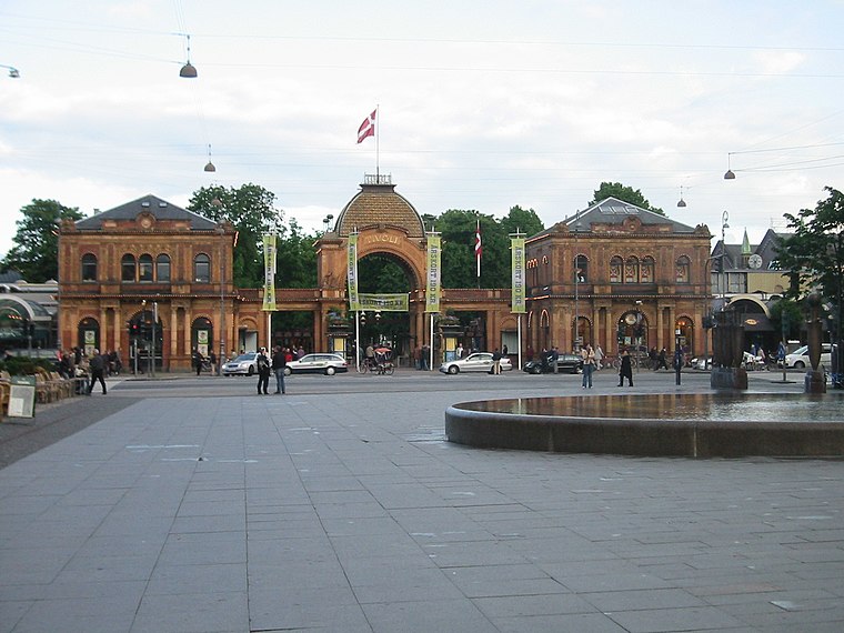
Photo: Elgaard, CC BY-SA 3.0.
Tivoli Gardens, also known simply as Tivoli, is an amusement park and pleasure garden in Copenhagen, Denmark. The park opened on 15 August 1843 and is the second-oldest operating amusement park in the world, after Dyrehavsbakken in nearby Klampenborg, also in Denmark. Tivoli Gardens is situated 2 km north of HavneBryggen Sirius.
Havneholmen
Islet
Havneholmen is a mixed-use development located on reclaimed land off Kalvebod Brygge in the harbor of Copenhagen, Denmark. It is located just east of the shopping centre Fisketorvet from which it is separated by a narrow canal, although it is annexed to mainland Kalvebod Brygge at its southern end. Havneholmen is situated 590 metres north of HavneBryggen Sirius.
Places in the Area
Nearby places include Enghave Brygge and Teglholmen.
Enghave Brygge
Neighborhood
Enghave Brygge is a waterfront area in the Southern Docklands of Copenhagen, Denmark. It is located between Vesterbro to the north and Frederiks Brygge to the south, and opposite Islands Brygge across the water.
Teglholmen
Neighborhood

Photo: seier seier, CC BY 2.0.
Teglholmen is a peninsula in the South Harbour of Copenhagen, Denmark, located between Sluseholmen and Enghave Brygge. The former dockland area used to house heavy industry.
Meatpacking District
Suburb

Photo: Riemann, Public domain.
Kødbyen is a district of Vesterbro in Copenhagen, Denmark. It is situated between the railway lines going into Copenhagen Central Station and Sønder Boulevard.
HavneBryggen Sirius
- Type: Building
- Location: Copenhagen municipality, Capital Region, Denmark, Nordic countries, Europe
- View on OpenStreetMap
Latitude
55.65629° or 55° 39′ 23″ northLongitude
12.56521° or 12° 33′ 55″ eastNamed after
SiriusOpen location code
9F7JMH48+G3OpenStreetMap ID
way 926841961OpenStreetMap feature
building=construction
This page is based on OpenStreetMap, Wikidata, and Wikimedia Commons.
We’d love your help improving our open data sources. Thank you for contributing.
Satellite Map
Discover HavneBryggen Sirius from above in high-definition satellite imagery.
Notable Places Nearby
Highlights include Sirius Plads and Viggo Kampmanns Plads.
Nearby Places
Explore places such as Føtex and JINSEI.
Denmark: Must-Visit Destinations
Delve into Copenhagen, Aarhus, Odense, and Aalborg.
Curious Buildings to Discover
Uncover intriguing buildings from every corner of the globe.
About Mapcarta. Data © OpenStreetMap contributors and available under the Open Database License". Text is available under the CC BY-SA 4.0 license, except for photos, directions, and the map. Photo: Wikimedia, CC BY-SA 3.0.