Ponte Ferroviária da Portela
Ponte Ferroviária da Portela is a bridge in Santo António dos Olivais, Coimbra. Ponte Ferroviária da Portela is situated nearby to the bridge Nova Ponte da Portela, as well as near the sports venue Health Club Fit & Fun.| Tap on a place to explore it |
Places of Interest Nearby
Highlights include Ceira River and Biblioteca Joanina.
Ceira River
River

Photo: Vitor Oliveira, CC BY-SA 2.0.
The Ceira River is a river in central Portugal arising out of the Serra do Açor. It is a lefthand tributary of the Mondego River, which it enters from the south, just upstream of the city of Coimbra.
Biblioteca Joanina
Library
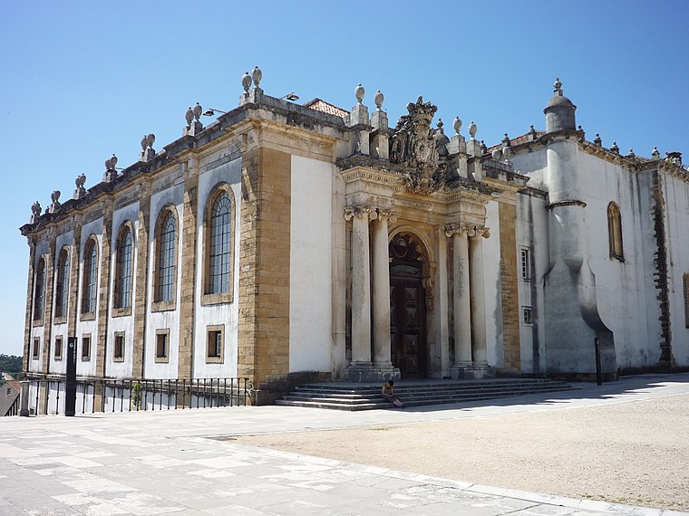
Photo: Chris, CC BY-SA 2.0.
The Biblioteca Joanina, sometimes known in English as the Joanine Library, is a Baroque library in Coimbra, Portugal, located at the heart of the University of Coimbra. Biblioteca Joanina is situated 3½ km northwest of Ponte Ferroviária da Portela.
Portugal dos Pequenitos
Theme park
Photo: Juntas, Public domain.
The Portugal dos Pequenitos is a miniature park in the civil parish of Santa Clara e Castelo Viegas, in the municipality of Coimbra, in the Portuguese district of Coimbra. Portugal dos Pequenitos is situated 4 km northwest of Ponte Ferroviária da Portela.
Places in the Area
Nearby places include Ceira and Torres do Mondego.
Ceira
Town
Ceira is a civil parish in Coimbra Municipality, Portugal. The population in 2011 was 3,701, in an area of 12.42 km2.
Torres do Mondego
Village

Photo: Inessaraiva, CC BY-SA 3.0.
Torres do Mondego is a civil parish in the municipality of Coimbra, Portugal. The population in 2021 was 2,034, in an area of 16.66 km2. It was established on 1 February 1934.
Cruzeiros de Celas
Suburb

Photo: Threeohsix, CC BY-SA 4.0.
Cruzeiros de Celas is a suburb, which is situated 3½ km northwest of Ponte Ferroviária da Portela.
Ponte Ferroviária da Portela
- Type: Bridge
- Category: transportation
- Location: Santo António dos Olivais, Coimbra, Coimbra District, Portugal, Iberia, Europe
- View on OpenStreetMap
Latitude
40.18438° or 40° 11′ 4″ northLongitude
-8.39563° or 8° 23′ 44″ westOpen location code
8CGH5JM3+PPOpenStreetMap ID
way 931950309OpenStreetMap feature
man_made=bridge
This page is based on OpenStreetMap, Wikidata, and Wikimedia Commons.
We’d love your help improving our open data sources. Thank you for contributing.
Satellite Map
Discover Ponte Ferroviária da Portela from above in high-definition satellite imagery.
Notable Places Nearby
Highlights include Nova Ponte da Portela and Health Club Fit & Fun.
Nearby Places
Explore places such as Portela (Rotunda) and Nicho Nossa Senhora da Conceição.
Portugal: Must-Visit Destinations
Delve into Lisbon, Caldas da Rainha, Porto, and Braga.
Curious Bridges to Discover
Uncover intriguing bridges from every corner of the globe.
About Mapcarta. Data © OpenStreetMap contributors and available under the Open Database License". Text is available under the CC BY-SA 4.0 license, except for photos, directions, and the map. Photo: Alvesgaspar, CC BY-SA 3.0.