Johanna-Quandt-Zentrum
Johanna-Quandt-Zentrum is a hospital building in Hesse, Germany. Johanna-Quandt-Zentrum is situated nearby to Japan Eagles Frankfurt, as well as near Main-Neckar bridge.| Tap on a place to explore it |
Places of Interest Nearby
Highlights include Frankfurt Hauptbahnhof and Städel.
Frankfurt Hauptbahnhof
Railway station
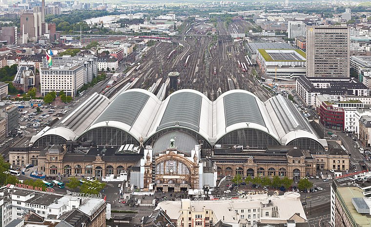
Photo: Der Wolf im Wald, CC BY-SA 3.0 de.
Frankfurt Hauptbahnhof is the busiest train station in the German state of Hesse and the second most busy train station in Germany behind Hamburg Hauptbahnhof. Frankfurt Hauptbahnhof is situated 1½ km north of Johanna-Quandt-Zentrum.
Städel
Museum

Photo: Simsalabimbam, CC BY-SA 3.0.
The Städel, officially the Städelsches Kunstinstitut und Städtische Galerie, is an art museum in Frankfurt, with one of the most important collections in Germany. Städel is situated 1½ km northeast of Johanna-Quandt-Zentrum.
Main-Neckar bridge
Bridge

Photo: Epizentrum, CC BY 3.0.
Main-Neckar bridge is situated 320 metres northwest of Johanna-Quandt-Zentrum.
Places in the Area
Nearby places include Niederrad and Bahnhofsviertel.
Niederrad
Suburb

Photo: PIERRE ANDRE LECLERCQ, CC BY-SA 4.0.
Niederrad is a quarter of Frankfurt am Main, Germany. It is part of the Ortsbezirk Süd and is subdivided into the Stadtbezirke Niederrad-Nord, Niederrad-Süd and the new Niederrad-West.
Bahnhofsviertel
Suburb

Photo: Luisfff2812, CC BY 4.0.
The Bahnhofsviertel is a quarter of Frankfurt am Main, Germany. It is part of the Ortsbezirk Innenstadt I. The Bahnhofsviertel was developed between 1891 and 1915.
Sachsenhausen
Suburb
Sachsenhausen-Nord and Sachsenhausen-Süd are two quarters of Frankfurt am Main, Germany. The division into a northern and a southern part is mostly for administrative purposes as Sachsenhausen is generally considered a single entity.
Johanna-Quandt-Zentrum
- Type: Hospital building
- Categories: building and health care
- Location: Hesse, Germany, Central Europe, Europe
- View on OpenStreetMap
Latitude
50.09403° or 50° 5′ 39″ northLongitude
8.65758° or 8° 39′ 27″ eastOpen location code
9F2C3MV5+J2OpenStreetMap ID
way 93465153OpenStreetMap feature
building=hospital
This page is based on OpenStreetMap, Wikidata, and Wikimedia Commons.
We’d love your help improving our open data sources. Thank you for contributing.
Satellite Map
Discover Johanna-Quandt-Zentrum from above in high-definition satellite imagery.
Notable Places Nearby
Highlights include Japan Eagles Frankfurt and Sportanlage Sandhöfer Wiesen.
Nearby Places
Explore places such as Haus 32C and Haus 28.
Hesse: Must-Visit Destinations
Delve into Frankfurt, Wiesbaden, Darmstadt, and Kassel.
Curious Places to Discover
Uncover intriguing places from every corner of the globe.
About Mapcarta. Data © OpenStreetMap contributors and available under the Open Database License". Text is available under the CC BY-SA 4.0 license, except for photos, directions, and the map. Photo: Pedelecs, CC BY-SA 3.0.