Pelzrain
Pelzrain is an allotment garden in Ettlingen, Karlsruhe, Baden-Württemberg. Pelzrain is situated nearby to the railway stop Ettlingen Neuwiesenreben, as well as near the church Neuapostolische Kirche.| Tap on a place to explore it |
Places of Interest Nearby
Highlights include Ettlingen Neuwiesenreben and Ettlingen West.
Ettlingen Neuwiesenreben
Railway stop
 Ettlingen Neuwiesenreben is a railway stop, which is situated 130 metres north of Pelzrain.
Ettlingen West
Railway station

Photo: Sitacuisses, CC BY-SA 3.0 de.
Ettlingen West is a railway station, which is situated 1 km southwest of Pelzrain.
Ettlingen Palace
Public building
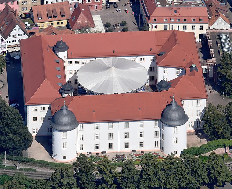
Photo: Carsten Steger, CC BY-SA 4.0.
Ettlingen Palace is a baroque palace in the centre of Ettlingen, a small city in Baden-Württemberg, Germany. Ettlingen Palace is situated 1¼ km south of Pelzrain.
Places in the Area
Nearby places include Wolfartsweier and Spessart.
Wolfartsweier
Suburb
Wolfartsweier is a village and a quarter of Karlsruhe, Baden-Württemberg, Germany. Its population is 3,068. It was first mentioned in 1261 AD under the name of "Wolvoldeswilere". Wolfartsweier is situated 5 km northeast of Pelzrain.
Spessart
Village

Photo: Elwood j blues, CC BY-SA 3.0.
Spessart is a village, which is situated 5 km southeast of Pelzrain.
Waldbronn
Town

Photo: Spacefrank, CC BY-SA 2.5.
Waldbronn is a municipality in the district of Karlsruhe, in Baden-Württemberg, Germany. It is situated in the northern Black Forest, 11 kilometres southeast of Karlsruhe. Waldbronn is situated 6 km southeast of Pelzrain.
Pelzrain
Latitude
48.95198° or 48° 57′ 7″ northLongitude
8.39994° or 8° 23′ 60″ eastOpen location code
8FWCX92X+QXOpenStreetMap ID
way 943546622OpenStreetMap feature
landuse=allotments
This page is based on OpenStreetMap, Wikidata, and Wikimedia Commons.
We’d love your help improving our open data sources. Thank you for contributing.
Satellite Map
Discover Pelzrain from above in high-definition satellite imagery.
Places with the Same Name
Discover other places named “Pelzrain”.
Notable Places Nearby
Highlights include Neuwiesen and Neuapostolische Kirche.
Nearby Places
Explore places such as Ettlingen Neuwiesenreben and Ettlingen Breitscheidstraße.
Rhine-Neckar: Must-Visit Destinations
Delve into Heidelberg, Karlsruhe, Mannheim, and Heilbronn.
Curious Allotment Gardens to Discover
Uncover intriguing allotment gardens from every corner of the globe.
About Mapcarta. Data © OpenStreetMap contributors and available under the Open Database License". Text is available under the CC BY-SA 4.0 license, except for photos, directions, and the map. Photo: Martin-D, CC BY-SA 2.5.