Saint Mary Roman Catholic Church
Saint Mary Roman Catholic Church is a church in Town of Stonington, Southeastern Connecticut Planning Region, Connecticut which is located on Broad Street. Saint Mary Roman Catholic Church is situated nearby to Stonington Post Office, as well as near Stonington Free Library Association.| Tap on a place to explore it |
- Type: Church
- Denomination: Roman Catholic
- Address: 22 Broad Street, Stonington, CT 06378
Places of Interest Nearby
Highlights include Capt. Nathaniel B. Palmer House and James Merrill House.
Capt. Nathaniel B. Palmer House
Museum
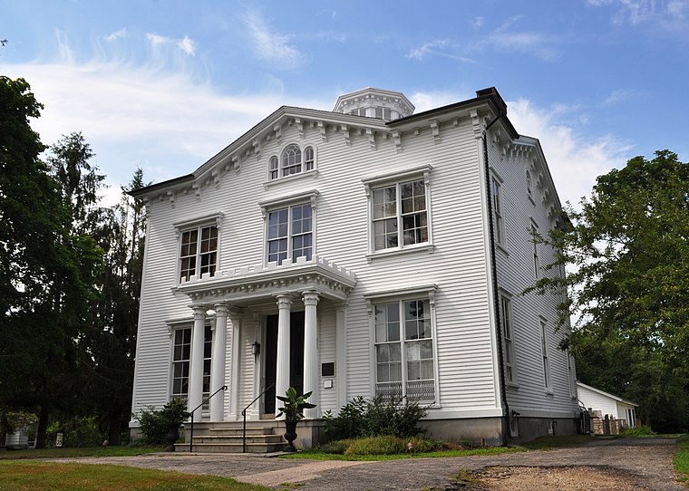
Photo: Wikimedia, CC BY-SA 3.0.
The Capt. Nathaniel B. Palmer House is a historic house museum in Stonington, Connecticut, built in 1852–54. The house is a transitional style between the Greek Revival and the Victorian Italianate. Capt. Nathaniel B. Palmer House is situated 2,100 feet north of Saint Mary Roman Catholic Church.
James Merrill House
Building

Photo: Logatorial, CC BY-SA 3.0.
The James Merrill House is a 19th-century late-Victorian style house at 107 Water Street in Stonington Borough in southeastern Connecticut, formerly owned by poet James Merrill. James Merrill House is situated 1,200 feet south of Saint Mary Roman Catholic Church.
Elihu Island
Island
Elihu Island is a private island off the coast of Stonington, Connecticut. It is located in Wequetequock Cove, just southwest of Goat Island and northeast of the western tip of Sandy Point Island.
Places in the Area
Nearby places include Stonington and Stonington.
Stonington

Photo: Pi.1415926535, CC BY-SA 3.0.
Stonington is a town located on Long Island Sound in New London County, Connecticut, United States. The municipal limits of the town include the borough of Stonington, the villages of Pawcatuck, Lords Point, and Wequetequock, and the eastern halves of the villages of Mystic and Old Mystic.
Stonington
Town
Stonington is a borough and the town center of Stonington, Connecticut, United States, referred to by locals as "The Borough". The population was 976 at the 2020 United States Census, up from 929 in 2010.
Lords Point
Suburb

Photo: Utilizer, CC BY-SA 4.0.
Lords Point is a small private village on the Atlantic Coast in the town of Stonington, Connecticut, United States, established in 1909. Lords Point has over 200 houses and summer cottages, with an average summer population of 800 people.
Saint Mary Roman Catholic Church
- Categories: building, place of worship, and religion
- Location: Town of Stonington, Southeastern Connecticut Planning Region, Connecticut, New England, United States, North America
- View on OpenStreetMap
Latitude
41.33713° or 41° 20′ 14″ northLongitude
-71.90633° or 71° 54′ 23″ westElevation
16 feet (5 metres)Open location code
87HC83PV+VFOpenStreetMap ID
way 948794652OpenStreetMap feature
amenity=place_of_worshipOpenStreetMap feature
building=yesOpenStreetMap attribute
denomination=roman_catholic
This page is based on OpenStreetMap, Wikidata, and Wikimedia Commons.
We’d love your help improving our open data sources. Thank you for contributing.
Satellite Map
Discover Saint Mary Roman Catholic Church from above in high-definition satellite imagery.
Places with the Same Name
Discover other places named “Saint Mary Roman Catholic Church”.
Notable Places Nearby
Highlights include Stonington Post Office and Stonington Free Library Association.
Nearby Places
Explore places such as Boat House and Borough Hall.
Connecticut: Must-Visit Destinations
Delve into Hartford, New Haven, Bridgeport, and Stamford.
Curious Churches to Discover
Uncover intriguing churches from every corner of the globe.
About Mapcarta. Data © OpenStreetMap contributors and available under the Open Database License". Text is available under the CC BY-SA 4.0 license, except for photos, directions, and the map. Photo: Wikimedia, CC0.