Moroccan Fountain
Moroccan Fountain is a fountain in Gibraltar. Moroccan Fountain is situated nearby to the fire station Gibraltar Fire and Rescue Service, as well as near Rotary Club Educational Garden.| Tap on a place to explore it |
Places of Interest Nearby
Highlights include The Rock and Trafalgar Cemetery.
The Rock
Peak
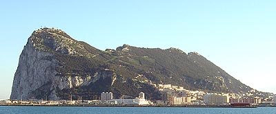
Photo: Gibnews, Public domain.
The Rock of Gibraltar is a monolithic limestone mountain 426 m high dominating the western entrance to the Mediterranean Sea. It is situated near the end of a narrow 9 kilometres -long promontory stretching due south into the Mediterranean Sea and is located within the British territory of Gibraltar.
Trafalgar Cemetery
Cemetery
The Trafalgar Cemetery is a cemetery in the British Overseas Territory of Gibraltar. Formerly known as the Southport Ditch Cemetery, it occupies a small area of land just to the south of the city walls, in what had been a defensive ditch during the period of Spanish rule of Gibraltar. Trafalgar Cemetery is situated 280 metres north of Moroccan Fountain.
Prince Edward’s Gate
City gate
Prince Edward's Gate is a city gate at the entrance to Prince Edward's Road in the British Overseas Territory of Gibraltar. It cuts through Charles V Wall, one of the 16th century fortifications of Gibraltar at the former southern limit of the city. Prince Edward’s Gate is situated 300 metres north of Moroccan Fountain.
Places in the Area
Nearby places include Coaling Island and South Mole.
Coaling Island
Locality

Photo: Mrjohncummings, CC BY-SA 3.0.
Coaling Island is an area of reclaimed land in the British Overseas Territory of Gibraltar. It is located at the centre of the western end of Gibraltar Harbour as one of its industrial zones.
South Mole
Locality

Photo: Itto Ogami, CC BY 3.0.
The South Mole is a breakwater located in the southern section of Gibraltar Harbour, in the British Overseas Territory of Gibraltar, at the southern end of the Iberian Peninsula.
East Side
Hamlet

Photo: Malcolm Tredinnick, CC BY 2.0.
Catalan Bay is a bay and fishing village in Gibraltar, on the eastern side of The Rock away from Westside.
Moroccan Fountain
- Type: Fountain
- Location: Gibraltar, Iberia, Europe
- View on OpenStreetMap
Latitude
36.13229° or 36° 7′ 56″ northLongitude
-5.35155° or 5° 21′ 6″ westOpen location code
8C8P4JJX+W9OpenStreetMap ID
way 966490708OpenStreetMap feature
amenity=fountain
This page is based on OpenStreetMap, Wikidata, and Wikimedia Commons.
We’d love your help improving our open data sources. Thank you for contributing.
Satellite Map
Discover Moroccan Fountain from above in high-definition satellite imagery.
Notable Places Nearby
Highlights include Gibraltar Fire and Rescue Service and Rotary Club Educational Garden.
Nearby Places
Explore places such as Crimean gun and The Nature Shop.
Curious Fountains to Discover
Uncover intriguing fountains from every corner of the globe.
About Mapcarta. Data © OpenStreetMap contributors and available under the Open Database License". Text is available under the CC BY-SA 4.0 license, except for photos, directions, and the map. Photo: Wikimedia, CC0.