Budynek maszynowni
Budynek maszynowni is an industrial building in Bolesławiec, Lower Silesian Voivodeship. Budynek maszynowni is situated nearby to the church Kaplica pw. Świętego Stanisława Kostki, as well as near Teren inwestycyjny I-UC1.| Tap on a place to explore it |
Places of Interest Nearby
Highlights include Bolesławiec rail viaduct and Bolesławiec railway station.
Bolesławiec rail viaduct
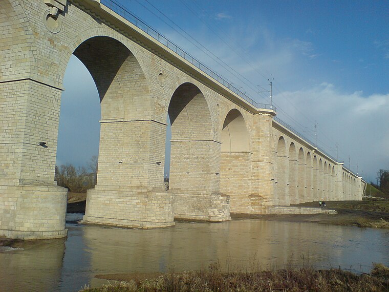
Photo: Antosh, Public domain.
The Bolesławiec rail viaduct is a railway bridge over the river Bóbr in Bolesławiec in Lower Silesia, Poland. Entirely made of stone, it is one of the longest bridges of its type in Poland and in Europe. Bolesławiec rail viaduct is situated 3½ km southwest of Budynek maszynowni.
Bolesławiec railway station
Railway station
Bolesławiec is a railway station in the town of Bolesławiec, Lower Silesia, Poland. Bolesławiec railway station is situated 3 km south of Budynek maszynowni.
Teatr Stary
Theater building

Photo: Antosh, CC BY-SA 3.0.
Teatr Stary is a theater building, which is situated 3½ km south of Budynek maszynowni.
Places in the Area
Nearby places include Łąka and Chościszowice.
Łąka
Village
Łąka is a village in the administrative district of Gmina Bolesławiec, within Bolesławiec County, Lower Silesian Voivodeship, in south-western Poland.
Chościszowice
Village
Chościszowice is a village in the administrative district of Gmina Bolesławiec, within Bolesławiec County, Lower Silesian Voivodeship, in south-western Poland.
Bolesławice
Village
Bolesławice is a village in the administrative district of Gmina Bolesławiec, within Bolesławiec County, Lower Silesian Voivodeship, in south-western Poland. Bolesławice is situated 2½ km southwest of Budynek maszynowni.
Budynek maszynowni
- Type: Industrial building
- Categories: building and industry
- Location: Bolesławiec, Bolesławiec County, Lower Silesian Voivodeship, Poland, Central Europe, Europe
- View on OpenStreetMap
Latitude
51.29313° or 51° 17′ 35″ northLongitude
15.57756° or 15° 34′ 39″ eastOpen location code
9F3Q7HVH+72OpenStreetMap ID
way 971397744OpenStreetMap feature
building=industrial
This page is based on OpenStreetMap, Wikidata, and Wikimedia Commons.
We’d love your help improving our open data sources. Thank you for contributing.
Satellite Map
Discover Budynek maszynowni from above in high-definition satellite imagery.
Notable Places Nearby
Highlights include Kaplica pw. Świętego Stanisława Kostki and Teren inwestycyjny I-UC1.
Nearby Places
Explore places such as Hala fabryczna 2 and Laboratorium.
Lower Silesian Voivodeship: Must-Visit Destinations
Delve into Wrocław, Legnica, Wałbrzych, and Głogów.
Curious Industrial Buildings to Discover
Uncover intriguing industrial buildings from every corner of the globe.
About Mapcarta. Data © OpenStreetMap contributors and available under the Open Database License". Text is available under the CC BY-SA 4.0 license, except for photos, directions, and the map. Photo: Enzo83, CC BY-SA 3.0 pl.