Strandkörbe
Strandkörbe is a seaside resort in Breege-Juliusruh, Landkreis Vorpommern-Rügen, Mecklenburg-Western Pomerania. Strandkörbe is situated nearby to the pitch Bouleplatz, as well as near the swimming pool Schwimmbad.| Tap on a place to explore it |
Places of Interest Nearby
Highlights include Pfarrkirche Altenkirchen.
Pfarrkirche Altenkirchen
Church
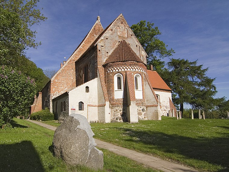
Photo: Unukorno, CC BY-SA 3.0.
Pfarrkirche Altenkirchen is a church, which is situated 3½ km northwest of Strandkörbe.
Places in the Area
Nearby places include Juliusruh and Altenkirchen.
Juliusruh
Village
Juliusruh is a village on the northern coast of the island of Rügen in northeastern Germany. Juliusruh is part of the municipality of Breege. Juliusruh and Breege combined have 821 inhabitants in an area of 15,99 km².
Altenkirchen

Photo: Chron-Paul, CC BY-SA 3.0.
Altenkirchen is a municipality in the north of the island of Rügen on the Baltic Sea coast of Germany. It is in the Vorpommern-Rügen district, in the federal state of Mecklenburg-Vorpommern.
Nobbin
Hamlet

Photo: Wikimedia, Public domain.
Nobbin is a village in the municipality of Putgarten on the Wittow peninsula on the German Baltic Sea island of Rügen. The village, comprising just a few houses, lies between the road from Altenkirchen to Arkona and the bay of Tromper Wiek. Nobbin is situated 4½ km north of Strandkörbe.
Strandkörbe
- Type: Seaside resort
- Categories: recreation area, accommodation, building, and tourism
- Location: Breege-Juliusruh, Landkreis Vorpommern-Rügen, Rügen, Mecklenburg-Western Pomerania, Germany, Central Europe, Europe
- View on OpenStreetMap
Latitude
54.61517° or 54° 36′ 55″ northLongitude
13.38134° or 13° 22′ 53″ eastOpen location code
9F6MJ98J+3GOpenStreetMap ID
way 982300692OpenStreetMap feature
leisure=beach_resort
This page is based on OpenStreetMap, Wikidata, and Wikimedia Commons.
We’d love your help improving our open data sources. Thank you for contributing.
Satellite Map
Discover Strandkörbe from above in high-definition satellite imagery.
Places with the Same Name
Discover other places named “Strandkörbe”.
Notable Places Nearby
Highlights include Bouleplatz and Schwimmbad.
Nearby Places
Explore places such as AQUAMARIS Strandresidenz Rügen Imbiss & Getränke and Morning (inclusive) & Evening (paid) Buffet.
Rügen: Must-Visit Destinations
Delve into Sassnitz, Bergen auf Rügen, Binz, and Putbus.
Curious Seaside Resorts to Discover
Uncover intriguing seaside resorts from every corner of the globe.
About Mapcarta. Data © OpenStreetMap contributors and available under the Open Database License". Text is available under the CC BY-SA 4.0 license, except for photos, directions, and the map. Photo: Traveler100, CC BY-SA 3.0.