Normandie-Cabourg-Pays d’Auge
Normandie-Cabourg-Pays d’Auge is a government building in Périers-en-Auge, Arrondissement of Lisieux, Normandy. Normandie-Cabourg-Pays d’Auge is situated nearby to the meadow Champs Messire Guillaume, as well as near the community center Centre Nelson Mandela.| Tap on a place to explore it |
- Opening hours: Monday—Friday 9:00 AM—noon and 2:00 PM—5:00 PM
- Email: accueil@ncpa.fr
- Type: Government building
- Also known as: “Communauté de communes Normandie-Cabourg-Pays d’Auge” and “NCPA”
Places of Interest Nearby
Highlights include Manoir Saint-Cloud and Halles de Dives-sur-Mer.
Manoir Saint-Cloud
Castle

Photo: Roi.dagobert, CC BY-SA 3.0.
Manoir Saint-Cloud is a castle, which is situated 780 metres north of Normandie-Cabourg-Pays d’Auge.
Halles de Dives-sur-Mer
Marketplace

Photo: Reinhardhauke, CC BY-SA 3.0.
Halles de Dives-sur-Mer is a marketplace, which is situated 1½ km north of Normandie-Cabourg-Pays d’Auge.
Dives-Cabourg station
Railway station
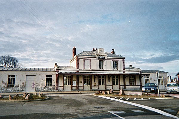
Photo: Captain Scarlet, CC BY 2.5.
Dives-Cabourg is the railway station for the towns of Dives-sur-Mer and Cabourg. The station is built in Ouest architecture and is a terminus for the Côte Fleurie branchline to Trouville-Deauville. Dives-Cabourg station is situated 2 km northwest of Normandie-Cabourg-Pays d’Auge.
Places in the Area
Nearby places include Dives-sur-Mer and Grangues.
Dives-sur-Mer
Town

Photo: Ikmo-ned, CC BY-SA 3.0.
Dives-sur-Mer is a commune in the Calvados department in Normandy in northwestern France.
Grangues
Village

Photo: Ikmo-ned, CC BY-SA 3.0.
Grangues is a commune in the Calvados department and Normandy region of north-western France. Grangues is situated 2½ km east of Normandie-Cabourg-Pays d’Auge.
Cricqueville-en-Auge
Village

Photo: Pimprenel, CC BY-SA 3.0.
Cricqueville-en-Auge is a commune in the Calvados department in the Normandy region in northwestern France. Cricqueville-en-Auge is situated 4 km southeast of Normandie-Cabourg-Pays d’Auge.
Normandie-Cabourg-Pays d’Auge
- Categories: government office, building, and office
- Location: Périers-en-Auge, Arrondissement of Lisieux, Calvados, Normandy, France, Europe
- View on OpenStreetMap
Latitude
49.27419° or 49° 16′ 27″ northLongitude
-0.09155° or 0° 5′ 30″ westLevels
2Open location code
8CXX7WF5+M9OpenStreetMap ID
way 98609184OpenStreetMap feature
building=governmentOpenStreetMap feature
office=government
This page is based on OpenStreetMap, Wikidata, and Wikimedia Commons.
We’d love your help improving our open data sources. Thank you for contributing.
Satellite Map
Discover Normandie-Cabourg-Pays d’Auge from above in high-definition satellite imagery.
Notable Places Nearby
Highlights include Bâtiment environnement de la communauté de communes Normandie Cabourg Pays d’Auge and Champs Messire Guillaume.
Nearby Places
Explore places such as ABAC-GÉO and Thierry Labe.
Normandy: Must-Visit Destinations
Delve into Orne, Rouen, Seine-Maritime, and Le Havre.
Curious Government Buildings to Discover
Uncover intriguing government buildings from every corner of the globe.
About Mapcarta. Data © OpenStreetMap contributors and available under the Open Database License". Text is available under the CC BY-SA 4.0 license, except for photos, directions, and the map. Photo: Inkey, CC BY-SA 3.0.