Gartenbau und Handwerken
Gartenbau und Handwerken is a school building in Wiesbaden, South Hesse, Hesse which is located on Mülhausener Straße. Gartenbau und Handwerken is situated nearby to the school Freie Waldorfschule Wiesbaden, as well as near Schulsporthalle Otto-Stückrath Grundschule.| Tap on a place to explore it |
- Type: School building
- Address: Mülhausener Straße 23, Wiesbaden, 65203
- Roof shape: gabled
- Wheelchair access: yes
Places of Interest Nearby
Highlights include Biebrich Palace and Schlosspark Biebrich.
Biebrich Palace

Photo: SBT, CC BY-SA 4.0.
Biebrich Palace is a Baroque residence in the borough of Biebrich in the city of Wiesbaden, Hesse, Germany. Built in 1702 by Prince Georg August Samuel of Nassau-Idstein, it served as the ducal residence for the independent Duchy of Nassau from 1816 until 1866. Biebrich Palace is situated 1 km southeast of Gartenbau und Handwerken.
Schlosspark Biebrich
Park
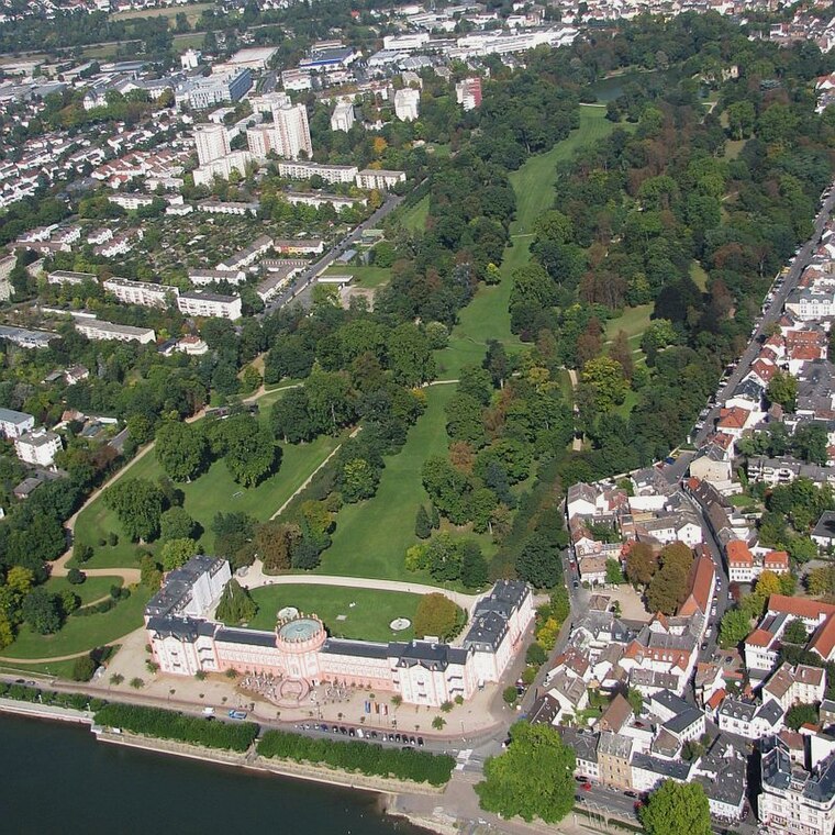
Photo: Wolfgang Pehlemann, CC BY-SA 3.0 de.
The Schlosspark Biebrich is a park at Schloss Biebrich in Wiesbaden-Biebrich, Hesse, Germany. First designed as a French formal garden, it was expanded changed to an English landscape garden and expanded 1817 to 1823, the last project of Friedrich Ludwig von Sckell. Schlosspark Biebrich is situated 780 metres east of Gartenbau und Handwerken.

Places in the Area
Nearby places include Biebrich and Schierstein.
Biebrich
Suburb
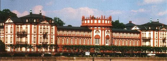
Photo: Wikimedia, Public domain.
Biebrich is a borough of the city of Wiesbaden, Hesse, Germany. With over 38,000 inhabitants, it is the most-populated of Wiesbaden's boroughs. It is located south of the city center on the Rhine River, opposite the Mainz borough of Mombach.
Schierstein
Suburb
 Schierstein is a southwestern borough of Wiesbaden, capital of state of Hesse, Germany. First mentioned in historical records in 860, Schierstein was incorporated into Wiesbaden in 1926.
Mainz-Amöneburg
Suburb
Photo: Wikimedia, CC BY-SA 3.0 de.
Mainz-Amöneburg is a district administered by the city of Wiesbaden, Germany. Its population is 1,743. Mainz-Amöneburg was formerly a district of the city of Mainz, until the public administration by the city of Wiesbaden was decided on August 10, 1945. Mainz-Amöneburg is situated 2½ km southeast of Gartenbau und Handwerken.
Gartenbau und Handwerken
- Categories: building and education
- Location: Wiesbaden, South Hesse, Hesse, Germany, Central Europe, Europe
- View on OpenStreetMap
Latitude
50.04412° or 50° 2′ 39″ northLongitude
8.22442° or 8° 13′ 28″ eastLevels
1Open location code
9F2C26VF+JQOpenStreetMap ID
way 99878548OpenStreetMap feature
building=schoolOpenStreetMap attribute
roof-shape=gabledOpenStreetMap attribute
wheelchair=yes
This page is based on OpenStreetMap, Wikidata, and Wikimedia Commons.
We’d love your help improving our open data sources. Thank you for contributing.
Satellite Map
Discover Gartenbau und Handwerken from above in high-definition satellite imagery.
Notable Places Nearby
Highlights include Freie Waldorfschule Wiesbaden and Höhle.
Nearby Places
Explore places such as Pizzaofen and Gewächshaus Gartenbau.
South Hesse: Must-Visit Destinations
Delve into Darmstadt, Bensheim, Lorsch, and Heppenheim.
Curious Places to Discover
Uncover intriguing places from every corner of the globe.
About Mapcarta. Data © OpenStreetMap contributors and available under the Open Database License". Text is available under the CC BY-SA 4.0 license, except for photos, directions, and the map. Photo: Pedelecs, CC BY-SA 3.0.