Gunnersbury
Gunnersbury es una estación de metro en Municipio de Hounslow, Londres, Inglaterra. Gunnersbury se encuentra cerca de la iglesia de Cathedral of the Nativity of the Mother of God and the Holy Royal Martyrs, así como de la estación de ferrocarril de Chiswick Park.| Toque un lugar para explorarlo |
Foto: Thryduulf, CC BY-SA 4.0.
- Tipo: estación de metro
- Descripción: estación del metro de Londres
- También conocido como: «Gunnersbury Station» y «Gunnersbury, South Acton»
- Acceso para silla de ruedas: limitado
Lugares de interés cercanos
Los puntos destacados incluyen Cathedral of the Nativity of the Mother of God and the Holy Royal Martyrs y Chiswick Park.
Cathedral of the Nativity of the Mother of God and the Holy Royal Martyrs
iglesia

Foto: The wub, CC BY-SA 4.0.
Cathedral of the Nativity of the Mother of God and the Holy Royal Martyrs es una iglesia, que se encuentra a 650 pies al sur de Gunnersbury.
Chiswick Park
estación de ferrocarril

Foto: Wikimedia, Public domain.
Chiswick Park es una estación de ferrocarril, que se encuentra a 2,100 pies al noreste de Gunnersbury.
Gunnersbury Triangle Local Nature Reserve
reserva natural

Foto: Chiswick Chap, CC BY-SA 3.0.
Gunnersbury Triangle Local Nature Reserve es una reserva natural.
Lugares en el área
Los lugares cercanos incluyen Grove Park y Chiswick.

Chiswick
villa
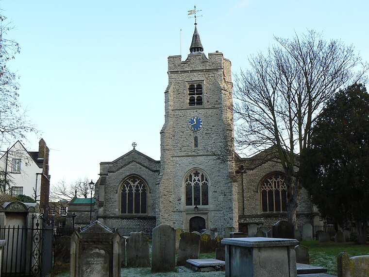
Foto: Patche99z, Public domain.
Chiswick es una zona adinerada del Oeste de Londres, Reino Unido, ubicada 9,5 km al oeste de Charing Cross, la cual cubre la parte oriental del municipio de Hounslow.…

Gunnersbury
- Categorías: estación del Metro de Londres, estación de ferrocarril, estación y transporte
- Ubicación: Municipio de Hounslow, Londres, Inglaterra, Reino Unido, Islas Británicas, Europa
- Ver en OpenStreetMap
Latitud
51.49138° o 51° 29′ 29″ norteLongitud
-0.27552° o 0° 16′ 32″ oesteAltitud
52 pies (16 metros)Operador
London UndergroundAbreviatura
«GUN»Open location code
9C3XFPRF+HQOpenStreetMap ID
node 6438904139Característica OpenStreetMap
public_transport=stationCaracterística OpenStreetMap
railway=stationAtributo OpenStreetMap
wheelchair=limitedGeoNames ID
6952702Wikidata ID
Q800858
Esta página se basa en OpenStreetMap, GeoNames, Wikidata y Wikimedia Commons.
Nos gustaría contar con su apoyo para mejorar nuestras fuentes de datos abiertas. Gracias por sus contribuciones.
Mapa satelital
Descubra Gunnersbury desde el aire en la vista satelital de alta definición.
En otros idiomas
Del alemán al yídish — «Gunnersbury» es conocida por muchos nombres.
- alemán: «Bahnhof Gunnersbury»
- árabe: «غونيرزبري (محطه مترو أنفاق لندن)»
- árabe: «غونيرزبري»
- checo: «Gunnersbury»
- chino: «古納斯伯里站»
- chino: «根拿斯贝利站»
- francés: «Gunnersbury, South Acton»
- francés: «Gunnersbury»
- húngaro: «Gunnersbury állomás»
- húngaro: «Gunnersbury»
- inglés: «GUN»
- inglés: «Gunnersbury railway station»
- inglés: «Gunnersbury station»
- inglés: «Gunnersbury tube station»
- inglés: «Gunnersbury Underground station»
- italiano: «stazione di Gunnersbury»
- italiano: «Stazione di Gunnersbury»
- japonés: «ガナーズベリー駅»
- japonés: «ガンナーズベリー駅»
- malayo: «Stesen Gunnersbury»
- neerlandés: «Station Gunnersbury»
- persa: «ایستگاه گانرزبوری»
- portugués: «Gunnersbury (Metropolitano de Londres)»
- portugués: «Gunnersbury»
- ucraniano: «Ганнерсбері»
- urdu: «گنرزبیری اسٹیشن»
- yídish: «גאנערסבורי סטאנציע»
- yídish: «גאַנערסבורי סטאַנציע»
- «GUN»
- «Gunnersbury»
- «Stazion de Gunnersbury»
- «甲諾斯巴雷站»
Localidades en el área
Explore destinos como Oxford Court y Chiswick Village.
Cerca de aquí
Explore destinos como Gunnersbury Underground Station y Gunnersbury.
Inglaterra: Destinos destacados
Conozca más sobre Londres, Mánchester, Sheffield y Leeds.
Lugares intrigantes por descubrir
Conozca lugares fascinantes en cada rincón del mundo.
Acerca de Mapcarta. Los datos © los colaboradores de OpenStreetMap y disponibles bajo la licencia Open Database. El texto está disponible bajo la licencia CC BY-SA 4.0, excepto las fotos, las direcciones y el mapa. Foto: Thryduulf, CC BY-SA 4.0.