Laurel and Marshall Streets District
Laurel and Marshall Streets District es un barrio en Town of Hartford, Región de Planificación del Capitolio, Connecticut. Laurel and Marshall Streets District se encuentra cerca del barrio de Nook Farm and Woodland Street Historic District, así como de Imlay and Laurel Streets District.| Toque un lugar para explorarlo |
Foto: Prakashkumar014, CC BY-SA 3.0.
Lugares de interés
Los puntos destacados incluyen Casa de Mark Twain y Harriet Beecher Stowe House.
Casa de Mark Twain
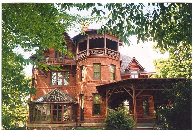
Foto: Makemake, CC BY-SA 3.0.
La Casa y Museo de Mark Twain fue el hogar de Mark Twain desde 1874 hasta 1891 en Hartford, Connecticut, Estados Unidos. Antes de 1871, momento en que se trasladaron a Hartford, Twain vivió en Hannibal, Misuri.
Harriet Beecher Stowe House
museo

Foto: Midnightdreary, CC BY-SA 3.0.
Harriet Beecher Stowe House es un museo.
Catedral de San José
iglesia
 La Catedral de San José es el nombre que recibe un templo católico en Hartford, Connecticut, Estados Unidos, es la iglesia madre de la arquidiócesis de Hartford.
Lugares en el área
Los lugares cercanos incluyen Nook Farm and Woodland Street Historic District y Imlay and Laurel Streets District.
Nook Farm and Woodland Street Historic District
barrio

Foto: Kzirkel, CC BY-SA 3.0.
Nook Farm and Woodland Street Historic District es un barrio.
Imlay and Laurel Streets District
barrio

Foto: Magicpiano, CC BY-SA 4.0.
Imlay and Laurel Streets District es un barrio.
Collins and Townley Streets Historic District
barrio

Foto: Prakashkumar014, CC BY-SA 3.0.
Collins and Townley Streets Historic District es un barrio.
Laurel and Marshall Streets District
- Tipo: barrio
- Categorías: centro histórico, área residencial, sitio histórico y localidad
- Ubicación: Town of Hartford, Región de Planificación del Capitolio, Connecticut, Nueva Inglaterra, Estados Unidos, Norteamérica
- Ver en OpenStreetMap
Latitud
41.76833° o 41° 46′ 6″ norteLongitud
-72.69778° o 72° 41′ 52″ oesteOpen location code
87H9Q892+8VOpenStreetMap ID
node 8908624119Característica OpenStreetMap
historic=districtCaracterística OpenStreetMap
place=neighbourhoodWikidata ID
Q38251046
Esta página se basa en OpenStreetMap, Wikidata y Wikimedia Commons.
Nos gustaría contar con su apoyo para mejorar nuestras fuentes de datos abiertas. Gracias por sus contribuciones.
Mapa satelital
Descubra Laurel and Marshall Streets District desde el aire en la vista satelital de alta definición.
En otros idiomas
«Laurel and Marshall Streets District» es conocida por muchos nombres.
- inglés: «Laurel and Marshall Streets District»
Localidades en el área
Explore destinos como Asylum Hill y Little Hollywood Historic District.
Lugares notables cercanos
Los puntos destacados incluyen Hartford Missionary Baptist Church y Christian Fellowship Seventh Day Adventist Church.
Connecticut: Destinos destacados
Conozca más sobre Hartford, New Haven, Bridgeport y Stamford.
Lugares intrigantes por descubrir
Conozca lugares fascinantes en cada rincón del mundo.
Acerca de Mapcarta. Los datos © los colaboradores de OpenStreetMap y disponibles bajo la licencia Open Database. El texto está disponible bajo la licencia CC BY-SA 4.0, excepto las fotos, las direcciones y el mapa. Foto: Prakashkumar014, CC BY-SA 3.0.