Hungerford
Hungerford is a historic market town and civil parish in Berkshire, England, 8 miles west of Newbury, 9 miles east of Marlborough, and 60 miles west of London.| Tap on a place to explore it |
Photo: Nigel Cox, CC BY-SA 2.0.
- Type: Town with 6,600 residents
- Description: market town and civil parish in Berkshire, England
- Also known as: “Hungerford, Berkshire”
Places of Interest
Highlights include Hungerford railway station and Hungerford Town Hall.
Hungerford railway station
Railway station
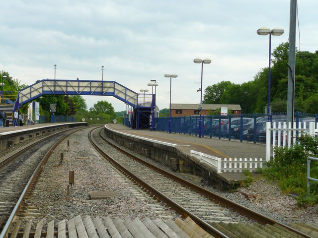
Photo: Chris Talbot, CC BY-SA 2.0.
Hungerford railway station is a railway station that serves the historic market town of Hungerford in Berkshire, England. It is 61 miles 43 chains measured from the zero point at London Paddington.
Hungerford Town Hall
Town hall

Photo: Chris Talbot, CC BY-SA 2.0.
Hungerford Town Hall is a municipal building in the High Street, Hungerford, Berkshire, England. The town hall, which is the meeting place of Hungerford Town Council, is a Grade II listed building.
Freeman’s Marsh
Freeman's Marsh is a 25.1-hectare biological Site of Special Scientific Interest on the northern outskirts of Hungerford in Berkshire, England. It is in the North Wessex Downs, which is an Area of Outstanding Natural Beauty.Places in the Area
Nearby places include Lower Denford and Upper Denford.
Lower Denford
Hamlet

Photo: Colin Bates, CC BY-SA 2.0.
Lower Denford is a hamlet in the civil parish of Kintbury in the English county of Berkshire. The settlement lies adjacent to the A4 road, and is located approximately 1 mile east of Hungerford.
Upper Denford
Hamlet
Upper Denford is a hamlet in Berkshire, England, and part of the civil parish of Kintbury. The settlement lies north of the A4 road, and is located approximately 1.5 miles north-east of Hungerford.
Leverton
Hamlet
 Leverton is a small hamlet in West Berkshire, England, close to the border with Wiltshire and around 2 mi north-west of Hungerford.
Hungerford
- Categories: civil parish, market town, and locality
- Location: West Berkshire, England, United Kingdom, Britain and Ireland, Europe
- View on OpenStreetMap
Latitude
51.4153° or 51° 24′ 55″ northLongitude
-1.5154° or 1° 30′ 55″ westPopulation
6,600Elevation
338 feet (103 metres)United Nations Location Code
GB HUFOpen location code
9C3WCF8M+4ROpenStreetMap ID
node 21517687OpenStreetMap feature
place=town
This page is based on OpenStreetMap, GeoNames, Wikidata, Wikimedia Commons, and Wikipedia.
We’d love your help improving our open data sources. Thank you for contributing.
Satellite Map
Discover Hungerford from above in high-definition satellite imagery.
In Other Languages
From Asturian to Welsh—“Hungerford” goes by many names.
- Asturian: “Hungerford”
- Basque: “Hungerford”
- Bengali: “হাঙ্গারফোর্ড”
- Cebuano: “Hungerford”
- Chinese: “Hungerford”
- Chinese: “亨格福德”
- Chinese: “亨格福特”
- Dutch: “Hungerford”
- Esperanto: “Hungerford”
- French: “Hungerford”
- German: “Hungerford”
- Gujarati: “હંગરફોર્ડ”
- Hebrew: “הונגרפורד”
- Irish: “Hungerford”
- Italian: “Hungerford”
- Japanese: “ハンガーフォード”
- Kannada: “ಹಂಗರ್ಫೋರ್ಡ್”
- Korean: “헝거포드”
- Kurdish: “Hungerford”
- Ladin: “Hungerford”
- Latin: “Hungerford”
- Lithuanian: “Hangerfordas”
- Min Nan Chinese: “Hungerford (Berkshire)”
- Norwegian Bokmål: “Hungerford”
- Norwegian Nynorsk: “Hungerford”
- Persian: “هانگرفورد”
- Polish: “Hungerford”
- Portuguese: “Hungerford”
- Romanian: “Hungerford”
- Russian: “Хангерфорд”
- Scots: “Hungerford”
- Serbo-Croatian: “Hungerford”
- South Azerbaijani: “هانقرفورد”
- Spanish: “Hungerford”
- Swedish: “Hungerford”
- Tamil: “ஹங்கேரிபோர்ட”
- Telugu: “హంగర్ ఫోర్డ్”
- Turkish: “Hungerford”
- Urdu: “ہنگر فورڈ”
- Urdu: “ہونجیرفورڈ”
- Volapük: “Hungerford (Berkshire)”
- Volapük: “Hungerford”
- Welsh: “Hungerford”
Places with the Same Name
Discover other places named “Hungerford”.
Localities in the Area
Explore places such as Down Gate and Eddington.
England: Must-Visit Destinations
Delve into London, Manchester, Sheffield, and Leeds.
Explore These Curated Destinations
Discover places selected for their distinct character and enduring appeal.
About Mapcarta. Data © OpenStreetMap contributors and available under the Open Database License". Text is available under the CC BY-SA 4.0 license, except for photos, directions, and the map. Description text is based on the Wikipedia page “Hungerford”. Photo: Nigel Cox, CC BY-SA 2.0.