Picnic Table
Picnic Table is a shelter in Marin County, California. Picnic Table is situated nearby to Sorich Ranch Park, as well as near the cliff Rock Fort.| Tap on a place to explore it |
Places of Interest Nearby
Highlights include Mount Tamalpais Cemetery and Terra Linda High School.
Mount Tamalpais Cemetery
Cemetery
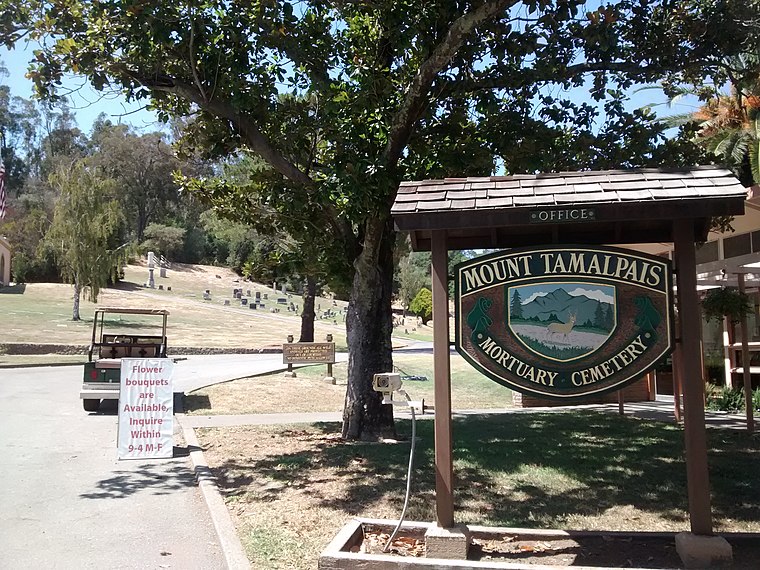
Photo: Mx. Granger, CC0.
Mount Tamalpais Cemetery is located in San Rafael, California. Mount Tamalpais Cemetery is situated 1,900 feet southeast of Picnic Table.
Terra Linda High School
School
 Terra Linda High School is a public secondary school located in Terra Linda, San Rafael, California, United States. In 2006, it was named a California Distinguished School. Terra Linda High School is situated 3,900 feet northeast of Picnic Table.
Mark Day School
School
San Rafael is a city in and the county seat of Marin County, California, United States. The city is located in the North Bay region of the San Francisco Bay Area. Mark Day School is situated 1¼ miles north of Picnic Table.
Places in the Area
Nearby places include Los Ranchitos and San Anselmo.
Los Ranchitos
Hamlet
Los Ranchitos is an unincorporated community in Marin County, California, United States. It lies at an elevation of 66 feet. Los Ranchitos was developed in 1949 into lots of at least one acre in size, with most averaging 1-2 acres.
San Anselmo
 San Anselmo is in Marin County in the San Francisco Bay Area of California. It's bordered on the east side by San Rafael, and the west side by Fairfax.
Fairfax

Photo: Traveler100, CC BY-SA 4.0.
Fairfax is a cute little town nestled in the hills of Marin County in the San Francisco Bay Area of California. Though small, it's surprisingly lively and has kept its historic charm.
Picnic Table
- Type: Shelter
- Location: Marin County, California, United States, North America
- View on OpenStreetMap
Latitude
37.99026° or 37° 59′ 25″ northLongitude
-122.56029° or 122° 33′ 37″ westOpen location code
849VXCRQ+4VOpenStreetMap ID
node 10003214210OpenStreetMap feature
amenity=shelter
This page is based on OpenStreetMap, Wikidata, and Wikimedia Commons.
We’d love your help improving our open data sources. Thank you for contributing.
Satellite Map
Discover Picnic Table from above in high-definition satellite imagery.
Places with the Same Name
Discover other places named “Picnic Table”.
Notable Places Nearby
Highlights include Sorich Ranch Park and Rock Fort.
Nearby Places
Explore places such as Redhill School and Sunny Hills Services.
Marin County: Must-Visit Destinations
Delve into Tiburon, Sausalito, San Rafael, and Novato.
Curious Shelters to Discover
Uncover intriguing shelters from every corner of the globe.
About Mapcarta. Data © OpenStreetMap contributors and available under the Open Database License". Text is available under the CC BY-SA 4.0 license, except for photos, directions, and the map. Photo: Sanfranman59, CC BY-SA 3.0.