Provincial Waterworks Authority Krabi Branch
Provincial Waterworks Authority Krabi Branch is a government office in Pak Nam, Mueang Krabi, Krabi Province. Provincial Waterworks Authority Krabi Branch is situated nearby to Krabi Provincial Prison, as well as near Wat Kaew Korawaram.| Tap on a place to explore it |
Places of Interest Nearby
Highlights include City Pillar Shrine and Khao Khanap Nam Cave.
City Pillar Shrine
Place of worship
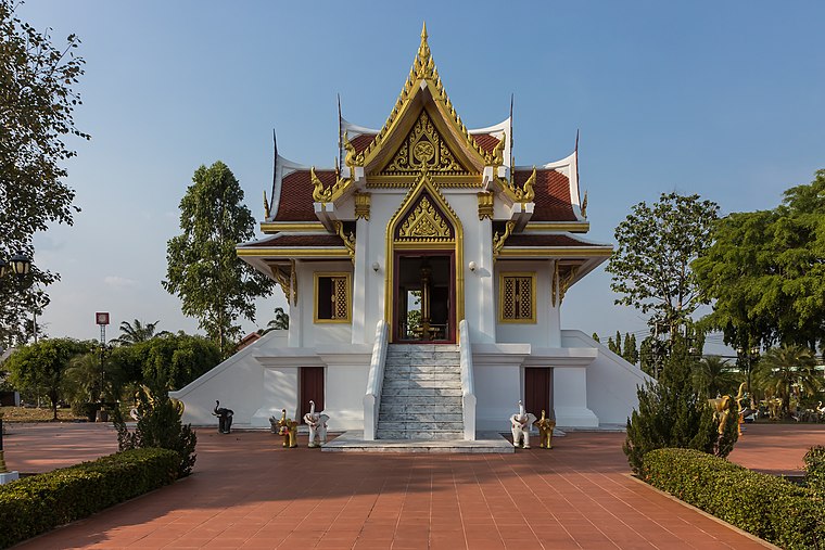
Photo: DerFussi, CC BY-SA 3.0.
City Pillar Shrine is a place of worship, which is situated 710 metres east of Provincial Waterworks Authority Krabi Branch.
Khao Khanap Nam Cave
Cave

Photo: Francesco Veronesi, CC BY-SA 2.0.
Khao Khanap Nam Cave is situated 2½ km northeast of Provincial Waterworks Authority Krabi Branch.
Places in the Area
Nearby places include Krabi Town and Rai Leh.
Krabi Town

Photo: Krauser levyl, CC BY-SA 3.0.
Krabi, the capital of Krabi Province, sits a little upstream from the mouth of the Krabi River and is mainly visited en route to the nearby beaches of Had Yao, Ao Nang or Rai Leh. Krabi is 784 km south of Bangkok by road.
Rai Leh

Photo: Kallerna, CC BY-SA 3.0.
Rai Leh, also commonly known as Railay or Rai Re, is a tourist area on the Andaman Coast of Thailand, in Krabi Province. Rai Leh is primarily known as a rock climbing hot spot, attracting climbers from all over the world to its superb towering limestone.
Provincial Waterworks Authority Krabi Branch
- Type: Government office
- Categories: office and government building
- Location: Pak Nam, Mueang Krabi, Krabi Province, Southern Thailand, Thailand, Southeast Asia, Asia
- View on OpenStreetMap
Latitude
8.05933° or 8° 3′ 34″ northLongitude
98.91153° or 98° 54′ 42″ eastOpen location code
6MWW3W56+PJOpenStreetMap ID
node 10208674902OpenStreetMap feature
office=government
This page is based on OpenStreetMap, Wikidata, and Wikimedia Commons.
We’d love your help improving our open data sources. Thank you for contributing.
Satellite Map
Discover Provincial Waterworks Authority Krabi Branch from above in high-definition satellite imagery.
In Other Languages
“Provincial Waterworks Authority Krabi Branch” goes by many names.
- Thai: “การประปาส่วนภูมิภาค สาขากระบี่”
Notable Places Nearby
Highlights include Krabi Provincial Prison and Wat Kaew Korawaram.
Nearby Places
Explore places such as Isaranuson School and 7 eleven.
Krabi Province: Must-Visit Destinations
Delve into Ko Lanta, Ko Phi Phi, Ao Nang, and Krabi Town.
Curious Government Offices to Discover
Uncover intriguing government offices from every corner of the globe.
About Mapcarta. Data © OpenStreetMap contributors and available under the Open Database License". Text is available under the CC BY-SA 4.0 license, except for photos, directions, and the map. Photo: Kallerna, CC BY-SA 3.0.