Ministerio de Transportes, Movilidad y Agenda Urbana
Ministerio de Transportes, Movilidad y Agenda Urbana is a government office in Chamberí, Madrid, Community of Madrid which is located on Paseo de la Castellana. Ministerio de Transportes, Movilidad y Agenda Urbana is situated nearby to the park Parque de Nuevos Ministerios, as well as near the art gallery La Arqueria de Nuevos Ministerios.| Tap on a place to explore it |
Places of Interest Nearby
Highlights include Nuevos Ministerios and Sorolla Museum.
Nuevos Ministerios
Station
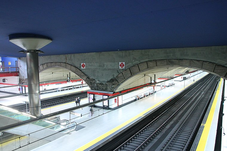
Photo: Draceane, CC BY-SA 4.0.
Nuevos Ministerios is a major multimodal rail station on the Madrid Metro and the Cercanías Madrid commuter rail network. It is located beneath the Nuevos Ministerios government complex and the AZCA financial centre at the junction of the Paseo de la Castellana and Joaquín Costa and Raimundo Fernández Villaverde streets in Madrid, Spain. Nuevos Ministerios is situated 260 metres northeast of Ministerio de Transportes, Movilidad y Agenda Urbana.
Sorolla Museum
Museum

Photo: Joaquín Sorolla, CC BY-SA 4.0.
The Sorolla Museum is a single-artist museum in Madrid, Spain, devoted to the work and life of Joaquín Sorolla and the members of his family, such as his daughter Elena. Sorolla Museum is situated 1 km south of Ministerio de Transportes, Movilidad y Agenda Urbana.
Embassy of Costa Rica
Government office

Photo: El Pantera, CC BY-SA 4.0.
Embassy of Costa Rica is a government office, which is situated 370 metres southwest of Ministerio de Transportes, Movilidad y Agenda Urbana.
Places in the Area
Nearby places include Ríos Rosas and El Viso.
Ríos Rosas
Quarter
 Ríos Rosas is a neighborhood of Madrid belonging to the district of Chamberí. It takes its name from Antonio de los Ríos Rosas, a 19th-century politician.
El Viso
Quarter
 El Viso is a neighborhood of Madrid, part of the Chamartín District. Consisting mainly of residential detached houses, it is currently the wealthiest neighborhood of the Spanish capital, overtaking the Salamanca District.
Cuatro Caminos
Quarter

Photo: Ramon Espiña Fernand…, CC BY-SA 3.0.
Cuatro Caminos is an administrative neighborhood of Madrid belonging to the district of Tetuán. It has an area of 1.193509 km2. As of 1 February 2020, it has a population of 35,395.
Ministerio de Transportes, Movilidad y Agenda Urbana
- Type: Government office
- Address: Paseo de la Castellana 67, Madrid, 28071
- Categories: office and government building
- Location: Chamberí, Madrid, Madrid, Community of Madrid, Central Spain, Spain, Iberia, Europe
- View on OpenStreetMap
Latitude
40.4445° or 40° 26′ 40″ northLongitude
-3.69349° or 3° 41′ 37″ westOpen location code
8CGRC8V4+RJOpenStreetMap ID
node 10543548230OpenStreetMap feature
office=government
This page is based on OpenStreetMap, Wikidata, and Wikimedia Commons.
We’d love your help improving our open data sources. Thank you for contributing.
Satellite Map
Discover Ministerio de Transportes, Movilidad y Agenda Urbana from above in high-definition satellite imagery.
Notable Places Nearby
Highlights include Parque de Nuevos Ministerios and La Arqueria de Nuevos Ministerios.
Nearby Places
Explore places such as Nuevos Ministerios-Castellana and Nuevos Ministerios Vía 8.
Madrid: Must-Visit Destinations
Delve into Sol-Letras-Lavapiés, Salamanca, Retiro-Paseo del Arte, and Chamberí-Castellana.
Curious Government Offices to Discover
Uncover intriguing government offices from every corner of the globe.
About Mapcarta. Data © OpenStreetMap contributors and available under the Open Database License". Text is available under the CC BY-SA 4.0 license, except for photos, directions, and the map. Photo: DonPaolo, CC BY-SA 3.0.